Ovakavağı geodata
Ovakavağı (Konya) is a populated place; located in Turkey in Europe/Istanbul (GMT+3) time zone. With population of 2,261 people, there are 916 cities with bigger population in this country. Compared to other cities in Turkey, 70.3% of cities are located further ↑North; 62.3% of cities are located further →East and 68.3% of cities have lower elevation than Ovakavağı. Note1


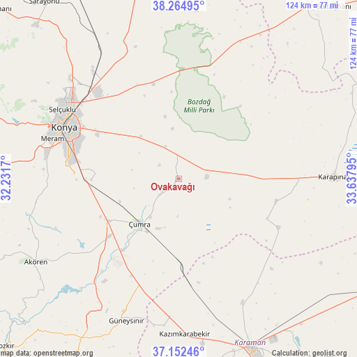
Ovakavağı GPS coordinates[2]
37° 42' 38.844" North, 32° 56' 5.352" East
| Map corner | latitude | longitude |
|---|---|---|
| Upper-left | 38.26495°, | 32.2317° |
| Center: | 37.71079°, | 32.93482° |
| Lower-right: | 37.15246°, | 33.63795° |
| Map W x H: | 123.7×123.7 km | = 76.9×76.9mi |
| max Lat: | 42.02683° ⇑70.3% North |
| Ovakavağı: | 37.71079° |
| min Lat: | ⇓29.7% South 35.9025° |
| min Long | Ovakavağı | max Long |
| 25.90902° | 32.93482° | 44.60099° |
| W 37.7%⇐ | ⇒62.3% E |
Elevation
Elevation of Ovakavağı is 1005 m = 3297 ft, and this is 287.6 m = 944 ft above average elevation for this country.
| Max E: |
2682 m = 8799 ft | 31.7% |
| Ovakavağı | 1005 m 3297 ft | |
| Avg. | 717.4 m = 2354 ft | |
Min E: |
0 m = 0 ft | 68.3% |
See also: Turkey elevation on elevation.city.
Geographical zone
Ovakavağı is located in North temperate zone (between Tropic of Cancer and the Arctic Circle). Distance of this Northern Tropic circle is 1587.1 km =986.2 mi to South.| Distance of | km | miles | from Ovakavağı |
|---|---|---|---|
| North Pole | 5814 | 3612.7 | to North |
| Arctic Circle | 3208.1 | 1993.4 | to North |
| Tropic Cancer | 1587.1 | 986.2 | to South |
| Equator | 4193 | 2605.4 | to South |


Nearby cities:
15 places around Ovakavağı: (largest is in red/bold)
• Aşağıpınarbaşı
46.8 km =29.1 mi,  321°
321°
• Dinek
51.3 km =31.9 mi,  213°
213°
• Güneysınır
52.3 km =32.5 mi,  200°
200°
• Hatip
45.3 km =28.1 mi,  276°
276°
• Hotamış
34.7 km =21.6 mi,  103°
103°
• Karatay
39.7 km =24.7 mi,  295°
295°
• Konya
43.4 km =27 mi,  294°
294°
• Kılbasan
48.3 km =30 mi,  152°
152°
• Meram
43.1 km =26.8 mi, 287°
• Selçuklu
43.4 km =27 mi, 296°
• Sille
51.2 km =31.8 mi, 298°
• Yarma
12.1 km =7.5 mi,  337°
337°
• Çatalhöyük
10.6 km =6.6 mi,  243°
243°
• Çiğil
42.5 km =26.4 mi,  127°
127°
• Çumra
20.8 km =12.9 mi,  222°
222°
Sources, notices
• [Note1] Compared only with cities in Turkey existing in our database
• [Src1] Map data: © OpenStreetMap contributors (CC-BY-SA)
• [Src2] Other city data from geonames.org with taken over terms of usage.
• [Src3] Geographical zone / Annual Mean Temperature by Robert A. Rohde @ Wikipedia
