Hotamış geodata
Hotamış (Konya) is a seat of a third-order administrative division; located in Turkey in Europe/Istanbul (GMT+3) time zone. In our database, there are 1323 cities with bigger population. Compared to other cities in Turkey, 71.6% of cities are located further ↑North; 61.1% of cities are located further →East and 68.4% of cities have lower elevation than Hotamış. Note1


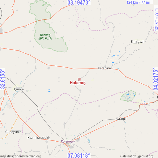
Hotamış GPS coordinates[2]
37° 38' 24.144" North, 33° 19' 7.032" East
| Map corner | latitude | longitude |
|---|---|---|
| Upper-left | 38.19473°, | 32.6155° |
| Center: | 37.64004°, | 33.31862° |
| Lower-right: | 37.08118°, | 34.02175° |
| Map W x H: | 123.8×123.8 km | = 76.9×76.9mi |
| max Lat: | 42.02683° ⇑71.6% North |
| Hotamış: | 37.64004° |
| min Lat: | ⇓28.4% South 35.9025° |
| min Long | Hotamış | max Long |
| 25.90902° | 33.31862° | 44.60099° |
| W 38.9%⇐ | ⇒61.1% E |
Elevation
Elevation of Hotamış is 1007 m = 3304 ft, and this is 289.6 m = 950 ft above average elevation for this country.
| Max E: |
2682 m = 8799 ft | 31.6% |
| Hotamış | 1007 m 3304 ft | |
| Avg. | 717.4 m = 2354 ft | |
Min E: |
0 m = 0 ft | 68.4% |
See also: Turkey elevation on elevation.city.
Geographical zone
Hotamış is located in North temperate zone (between Tropic of Cancer and the Arctic Circle). Distance of this Northern Tropic circle is 1579.3 km =981.3 mi to South.| Distance of | km | miles | from Hotamış |
|---|---|---|---|
| North Pole | 5821.9 | 3617.6 | to North |
| Arctic Circle | 3216 | 1998.3 | to North |
| Tropic Cancer | 1579.3 | 981.3 | to South |
| Equator | 4185.2 | 2600.6 | to South |


Nearby cities:
15 places around Hotamış: (largest is in red/bold)
• Ayrancı
45 km =28 mi,  133°
133°
• Beyviran
53 km =32.9 mi,  63°
63°
• Emirgazi
54.1 km =33.6 mi, 57°
• Karaman
51.8 km =32.2 mi,  190°
190°
• Karapınar
22.1 km =13.7 mi,  67°
67°
• Kazımkarabekir
55.5 km =34.5 mi,  214°
214°
• Kılbasan
36.9 km =22.9 mi,  198°
198°
• Obruk
61.7 km =38.3 mi,  348°
348°
• Ovakavağı
34.7 km =21.6 mi,  283°
283°
• Yarma
42.8 km =26.6 mi,  296°
296°
• Yeşildere
56.5 km =35.1 mi,  162°
162°
• Çatalhöyük
43.4 km =27 mi,  274°
274°
• Çiğil
17.9 km =11.1 mi,  180°
180°
• Çumra
48.5 km =30.1 mi,  261°
261°
• İnönü
53.4 km =33.2 mi, 132°
Sources, notices
• [Note1] Compared only with cities in Turkey existing in our database
• [Src1] Map data: © OpenStreetMap contributors (CC-BY-SA)
• [Src2] Other city data from geonames.org with taken over terms of usage.
• [Src3] Geographical zone / Annual Mean Temperature by Robert A. Rohde @ Wikipedia
