Battalgazi geodata
Battalgazi (Malatya) is a seat of a second-order administrative division; located in Turkey in Europe/Istanbul (GMT+3) time zone. In our database, there are 1323 cities with bigger population. Compared to other cities in Turkey, 53.9% of cities are located further ↑North; 63.5% of cities are located further ←West and 54.6% of cities have lower elevation than Battalgazi. Note1


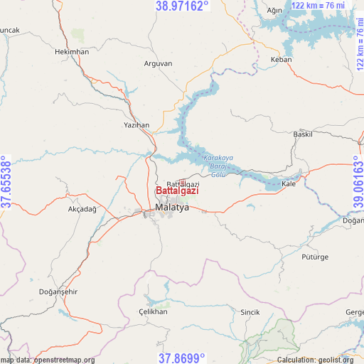
Battalgazi GPS coordinates[2]
38° 25' 22.296" North, 38° 21' 30.6" East
| Map corner | latitude | longitude |
|---|---|---|
| Upper-left | 38.97162°, | 37.65538° |
| Center: | 38.42286°, | 38.3585° |
| Lower-right: | 37.8699°, | 39.06163° |
| Map W x H: | 122.5×122.5 km | = 76.1×76.1mi |
| max Lat: | 42.02683° ⇑53.9% North |
| Battalgazi: | 38.42286° |
| min Lat: | ⇓46.1% South 35.9025° |
| min Long | Battalgazi | max Long |
| 25.90902° | 38.3585° | 44.60099° |
| W 63.5%⇐ | ⇒36.5% E |
Elevation
Elevation of Battalgazi is 784 m = 2572 ft, and this is 66.6 m = 219 ft above average elevation for this country.
| Max E: |
2682 m = 8799 ft | 45.4% |
| Battalgazi | 784 m 2572 ft | |
| Avg. | 717.4 m = 2354 ft | |
Min E: |
0 m = 0 ft | 54.6% |
See also: Turkey elevation on elevation.city.
Geographical zone
Battalgazi is located in North temperate zone (between Tropic of Cancer and the Arctic Circle). Distance of this Northern Tropic circle is 1666.3 km =1035.4 mi to South.| Distance of | km | miles | from Battalgazi |
|---|---|---|---|
| North Pole | 5734.8 | 3563.4 | to North |
| Arctic Circle | 3129 | 1944.3 | to North |
| Tropic Cancer | 1666.3 | 1035.4 | to South |
| Equator | 4272.2 | 2654.6 | to South |


Nearby cities:
15 places around Battalgazi: (largest is in red/bold)
• Akçadağ
35.1 km =21.8 mi,  254°
254°
• Arguvan
39.9 km =24.8 mi,  348°
348°
• Aydınlar
27.2 km =16.9 mi,  35°
35°
• Baskil
43 km =26.7 mi,  67°
67°
• Kale
35.9 km =22.3 mi,  91°
91°
• Kuşsarayı
28.1 km =17.5 mi,  83°
83°
• Levent
43.9 km =27.3 mi,  272°
272°
• Malatya
8.9 km =5.5 mi,  204°
204°
• Taşdelen
47.9 km =29.8 mi,  15°
15°
• Tepehan
46.7 km =29 mi,  136°
136°
• Yarpuzlu
43.4 km =27 mi,  160°
160°
• Yazıhan
24.8 km =15.4 mi,  319°
319°
• Yeşilyurt
17.2 km =10.7 mi,  214°
214°
• Çelikhan
45.4 km =28.2 mi,  193°
193°
• Çolaklı
17.2 km =10.7 mi,  125°
125°
Sources, notices
• [Note1] Compared only with cities in Turkey existing in our database
• [Src1] Map data: © OpenStreetMap contributors (CC-BY-SA)
• [Src2] Other city data from geonames.org with taken over terms of usage.
• [Src3] Geographical zone / Annual Mean Temperature by Robert A. Rohde @ Wikipedia
