Levent geodata
Levent (Malatya) is a seat of a third-order administrative division; located in Turkey in Europe/Istanbul (GMT+3) time zone. In our database, there are 1323 cities with bigger population. Compared to other cities in Turkey, 53.8% of cities are located further ↑North; 60.8% of cities are located further ←West and 86.5% of cities have lower elevation than Levent. Note1


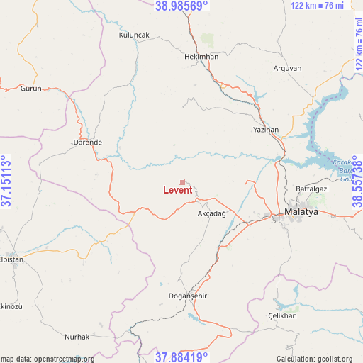
Levent GPS coordinates[2]
38° 26' 13.344" North, 37° 51' 15.3" East
| Map corner | latitude | longitude |
|---|---|---|
| Upper-left | 38.98569°, | 37.15113° |
| Center: | 38.43704°, | 37.85425° |
| Lower-right: | 37.88419°, | 38.55738° |
| Map W x H: | 122.5×122.5 km | = 76.1×76.1mi |
| max Lat: | 42.02683° ⇑53.8% North |
| Levent: | 38.43704° |
| min Lat: | ⇓46.2% South 35.9025° |
| min Long | Levent | max Long |
| 25.90902° | 37.85425° | 44.60099° |
| W 60.8%⇐ | ⇒39.2% E |
Elevation
Elevation of Levent is 1356 m = 4449 ft, and this is 638.6 m = 2095 ft above average elevation for this country.
| Max E: |
2682 m = 8799 ft | 13.5% |
| Levent | 1356 m 4449 ft | |
| Avg. | 717.4 m = 2354 ft | |
Min E: |
0 m = 0 ft | 86.5% |
See also: Turkey elevation on elevation.city.
Geographical zone
Levent is located in North temperate zone (between Tropic of Cancer and the Arctic Circle). Distance of this Northern Tropic circle is 1667.9 km =1036.4 mi to South.| Distance of | km | miles | from Levent |
|---|---|---|---|
| North Pole | 5733.3 | 3562.5 | to North |
| Arctic Circle | 3127.4 | 1943.3 | to North |
| Tropic Cancer | 1667.9 | 1036.4 | to South |
| Equator | 4273.8 | 2655.6 | to South |


Nearby cities:
15 places around Levent: (largest is in red/bold)
• Akçadağ
14.9 km =9.3 mi,  137°
137°
• Arguvan
51.6 km =32.1 mi,  43°
43°
• Balaban
24.1 km =15 mi,  276°
276°
• Battalgazi
43.9 km =27.3 mi,  92°
92°
• Darende
32.6 km =20.3 mi,  291°
291°
• Doğanşehir
39.1 km =24.3 mi,  177°
177°
• Gücük
42.3 km =26.3 mi,  230°
230°
• Hekimhan
42.7 km =26.5 mi,  8°
8°
• Kuluncak
51.6 km =32.1 mi,  341°
341°
• Kurşunlu
24 km =14.9 mi,  359°
359°
• Kürecik
14.9 km =9.3 mi,  221°
221°
• Malatya
41.4 km =25.7 mi,  103°
103°
• Sürgü
48.9 km =30.4 mi,  168°
168°
• Yazıhan
32.7 km =20.3 mi,  58°
58°
• Yeşilyurt
37.5 km =23.3 mi,  114°
114°
Sources, notices
• [Note1] Compared only with cities in Turkey existing in our database
• [Src1] Map data: © OpenStreetMap contributors (CC-BY-SA)
• [Src2] Other city data from geonames.org with taken over terms of usage.
• [Src3] Geographical zone / Annual Mean Temperature by Robert A. Rohde @ Wikipedia
