Akçadağ geodata
Akçadağ (Malatya) is a seat of a second-order administrative division; located in Turkey in Europe/Istanbul (GMT+3) time zone. With population of 14,788 people, there are 395 cities with bigger population in this country. Compared to other cities in Turkey, 55.4% of cities are located further ↑North; 61.5% of cities are located further ←West and 72.7% of cities have lower elevation than Akçadağ. Note1


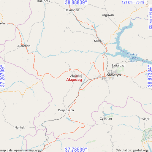
Akçadağ GPS coordinates[2]
38° 20' 20.364" North, 37° 58' 12.756" East
| Map corner | latitude | longitude |
|---|---|---|
| Upper-left | 38.88839°, | 37.26709° |
| Center: | 38.33899°, | 37.97021° |
| Lower-right: | 37.78539°, | 38.67334° |
| Map W x H: | 122.6×122.6 km | = 76.2×76.2mi |
| max Lat: | 42.02683° ⇑55.4% North |
| Akçadağ: | 38.33899° |
| min Lat: | ⇓44.6% South 35.9025° |
| min Long | Akçadağ | max Long |
| 25.90902° | 37.97021° | 44.60099° |
| W 61.5%⇐ | ⇒38.5% E |
Elevation
Elevation of Akçadağ is 1067 m = 3501 ft, and this is 349.6 m = 1147 ft above average elevation for this country.
| Max E: |
2682 m = 8799 ft | 27.3% |
| Akçadağ | 1067 m 3501 ft | |
| Avg. | 717.4 m = 2354 ft | |
Min E: |
0 m = 0 ft | 72.7% |
See also: Turkey elevation on elevation.city.
Geographical zone
Akçadağ is located in North temperate zone (between Tropic of Cancer and the Arctic Circle). Distance of this Northern Tropic circle is 1657 km =1029.6 mi to South.| Distance of | km | miles | from Akçadağ |
|---|---|---|---|
| North Pole | 5744.2 | 3569.3 | to North |
| Arctic Circle | 3138.3 | 1950 | to North |
| Tropic Cancer | 1657 | 1029.6 | to South |
| Equator | 4262.9 | 2648.8 | to South |


Nearby cities:
15 places around Akçadağ: (largest is in red/bold)
• Balaban
36.7 km =22.8 mi,  291°
291°
• Battalgazi
35.1 km =21.8 mi,  74°
74°
• Darende
46.5 km =28.9 mi,  299°
299°
• Doğanşehir
29.5 km =18.3 mi,  197°
197°
• Gücük
45.6 km =28.3 mi,  249°
249°
• Koçali
52.6 km =32.7 mi,  151°
151°
• Kurşunlu
36.5 km =22.7 mi,  343°
343°
• Kürecik
20 km =12.4 mi,  269°
269°
• Levent
14.9 km =9.3 mi,  317°
317°
• Malatya
30.2 km =18.8 mi,  87°
87°
• Sürgü
37.1 km =23.1 mi,  180°
180°
• Yazıhan
33.3 km =20.7 mi,  32°
32°
• Yeşilyurt
24.5 km =15.2 mi,  101°
101°
• Çelikhan
41.9 km =26 mi, 146°
• Çolaklı
47.9 km =29.8 mi, 90°
Sources, notices
• [Note1] Compared only with cities in Turkey existing in our database
• [Src1] Map data: © OpenStreetMap contributors (CC-BY-SA)
• [Src2] Other city data from geonames.org with taken over terms of usage.
• [Src3] Geographical zone / Annual Mean Temperature by Robert A. Rohde @ Wikipedia
