Aydınlar geodata
Aydınlar (Elazığ) is a seat of a third-order administrative division; located in Turkey in Europe/Istanbul (GMT+3) time zone. In our database, there are 1323 cities with bigger population. Compared to other cities in Turkey, 51.3% of cities are located further ↑North; 64.4% of cities are located further ←West and 83.5% of cities have lower elevation than Aydınlar. Note1


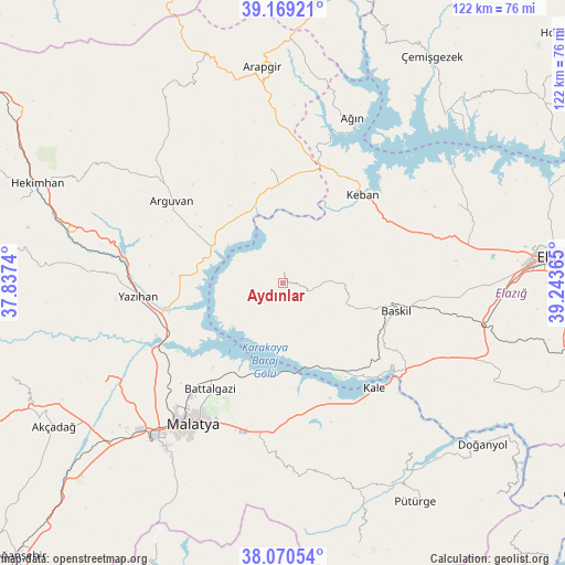
Aydınlar GPS coordinates[2]
38° 37' 19.128" North, 38° 32' 25.872" East
| Map corner | latitude | longitude |
|---|---|---|
| Upper-left | 39.16921°, | 37.8374° |
| Center: | 38.62198°, | 38.54052° |
| Lower-right: | 38.07054°, | 39.24365° |
| Map W x H: | 122.2×122.2 km | = 75.9×75.9mi |
| max Lat: | 42.02683° ⇑51.3% North |
| Aydınlar: | 38.62198° |
| min Lat: | ⇓48.7% South 35.9025° |
| min Long | Aydınlar | max Long |
| 25.90902° | 38.54052° | 44.60099° |
| W 64.4%⇐ | ⇒35.6% E |
Elevation
Elevation of Aydınlar is 1273 m = 4177 ft, and this is 555.6 m = 1823 ft above average elevation for this country.
| Max E: |
2682 m = 8799 ft | 16.5% |
| Aydınlar | 1273 m 4177 ft | |
| Avg. | 717.4 m = 2354 ft | |
Min E: |
0 m = 0 ft | 83.5% |
See also: Turkey elevation on elevation.city.
Geographical zone
Aydınlar is located in North temperate zone (between Tropic of Cancer and the Arctic Circle). Distance of this Northern Tropic circle is 1688.4 km =1049.1 mi to South.| Distance of | km | miles | from Aydınlar |
|---|---|---|---|
| North Pole | 5712.7 | 3549.7 | to North |
| Arctic Circle | 3106.8 | 1930.5 | to North |
| Tropic Cancer | 1688.4 | 1049.1 | to South |
| Equator | 4294.4 | 2668.4 | to South |


Nearby cities:
15 places around Aydınlar: (largest is in red/bold)
• Arguvan
29.4 km =18.3 mi,  305°
305°
• Ağın
38.1 km =23.7 mi,  22°
22°
• Baskil
24.7 km =15.3 mi,  103°
103°
• Battalgazi
27.2 km =16.9 mi,  215°
215°
• Hankendi
45.3 km =28.1 mi, 97°
• Hıdırbaba
41.2 km =25.6 mi,  66°
66°
• Kale
30.5 km =19 mi,  138°
138°
• Keban
25.5 km =15.8 mi,  41°
41°
• Kuşsarayı
22.5 km =14 mi,  147°
147°
• Malatya
36 km =22.4 mi,  212°
212°
• Poyraz
42.5 km =26.4 mi,  80°
80°
• Taşdelen
24.2 km =15 mi,  352°
352°
• Yazıhan
32.1 km =19.9 mi,  264°
264°
• Yeşilyurt
44.4 km =27.6 mi, 215°
• Çolaklı
32.1 km =19.9 mi,  183°
183°
Sources, notices
• [Note1] Compared only with cities in Turkey existing in our database
• [Src1] Map data: © OpenStreetMap contributors (CC-BY-SA)
• [Src2] Other city data from geonames.org with taken over terms of usage.
• [Src3] Geographical zone / Annual Mean Temperature by Robert A. Rohde @ Wikipedia
