Yazıhan geodata
Yazıhan (Malatya) is a seat of a second-order administrative division; located in Turkey in Europe/Istanbul (GMT+3) time zone. With population of 5,156 people, there are 708 cities with bigger population in this country. Compared to other cities in Turkey, 51.7% of cities are located further ↑North; 62.5% of cities are located further ←West and 56.9% of cities have lower elevation than Yazıhan. Note1


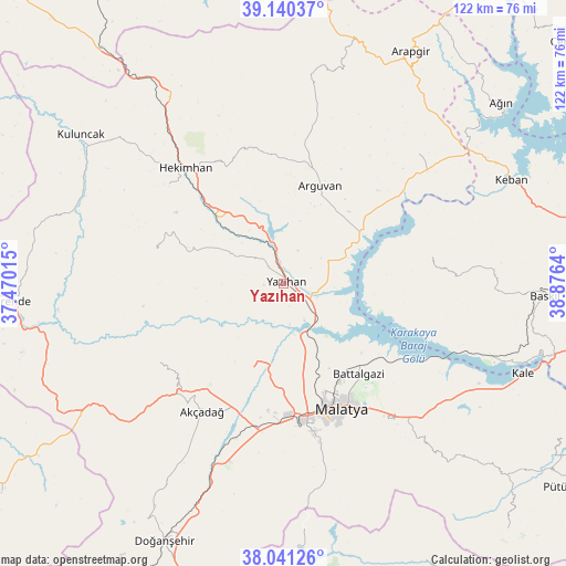
Yazıhan GPS coordinates[2]
38° 35' 34.512" North, 38° 10' 23.772" East
| Map corner | latitude | longitude |
|---|---|---|
| Upper-left | 39.14037°, | 37.47015° |
| Center: | 38.59292°, | 38.17327° |
| Lower-right: | 38.04126°, | 38.8764° |
| Map W x H: | 122.2×122.2 km | = 75.9×75.9mi |
| max Lat: | 42.02683° ⇑51.7% North |
| Yazıhan: | 38.59292° |
| min Lat: | ⇓48.3% South 35.9025° |
| min Long | Yazıhan | max Long |
| 25.90902° | 38.17327° | 44.60099° |
| W 62.5%⇐ | ⇒37.5% E |
Elevation
Elevation of Yazıhan is 826 m = 2710 ft, and this is 108.6 m = 356 ft above average elevation for this country.
| Max E: |
2682 m = 8799 ft | 43.1% |
| Yazıhan | 826 m 2710 ft | |
| Avg. | 717.4 m = 2354 ft | |
Min E: |
0 m = 0 ft | 56.9% |
See also: Turkey elevation on elevation.city.
Geographical zone
Yazıhan is located in North temperate zone (between Tropic of Cancer and the Arctic Circle). Distance of this Northern Tropic circle is 1685.2 km =1047.1 mi to South.| Distance of | km | miles | from Yazıhan |
|---|---|---|---|
| North Pole | 5715.9 | 3551.7 | to North |
| Arctic Circle | 3110 | 1932.5 | to North |
| Tropic Cancer | 1685.2 | 1047.1 | to South |
| Equator | 4291.1 | 2666.4 | to South |


Nearby cities:
15 places around Yazıhan: (largest is in red/bold)
• Akçadağ
33.3 km =20.7 mi,  212°
212°
• Arguvan
21.6 km =13.4 mi,  21°
21°
• Aydınlar
32.1 km =19.9 mi,  84°
84°
• Battalgazi
24.8 km =15.4 mi,  139°
139°
• Hasançelebi
47.2 km =29.3 mi,  327°
327°
• Hekimhan
32.7 km =20.3 mi,  319°
319°
• Kurşunlu
28.8 km =17.9 mi,  283°
283°
• Kuşsarayı
46.7 km =29 mi,  109°
109°
• Kürecik
47.2 km =29.3 mi,  232°
232°
• Levent
32.7 km =20.3 mi,  238°
238°
• Malatya
29.7 km =18.5 mi,  155°
155°
• Taşdelen
39.6 km =24.6 mi,  46°
46°
• Yeşilyurt
33.6 km =20.9 mi,  169°
169°
• Yoncalı
46.8 km =29.1 mi,  8°
8°
• Çolaklı
41.7 km =25.9 mi,  133°
133°
Sources, notices
• [Note1] Compared only with cities in Turkey existing in our database
• [Src1] Map data: © OpenStreetMap contributors (CC-BY-SA)
• [Src2] Other city data from geonames.org with taken over terms of usage.
• [Src3] Geographical zone / Annual Mean Temperature by Robert A. Rohde @ Wikipedia
