Yeşilyurt geodata
Yeşilyurt (Malatya) is a seat of a third-order administrative division; located in Turkey in Europe/Istanbul (GMT+3) time zone. With population of 13,766 people, there are 414 cities with bigger population in this country. Compared to other cities in Turkey, 56.2% of cities are located further ↑North; 62.8% of cities are located further ←West and 67.2% of cities have lower elevation than Yeşilyurt. Note1


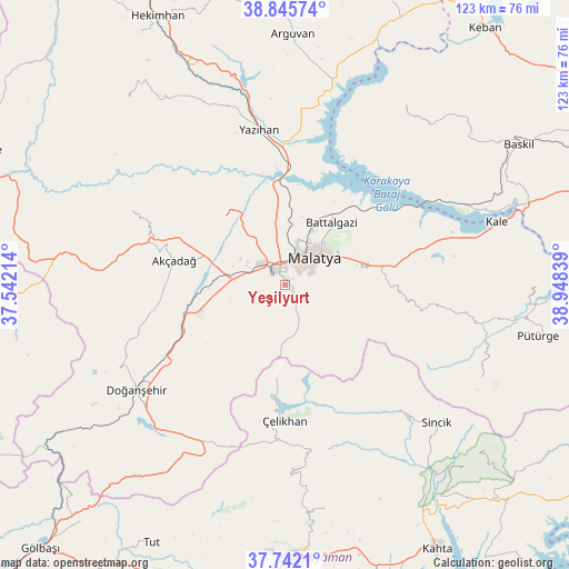
Yeşilyurt GPS coordinates[2]
38° 17' 45.672" North, 38° 14' 42.936" East
| Map corner | latitude | longitude |
|---|---|---|
| Upper-left | 38.84574°, | 37.54214° |
| Center: | 38.29602°, | 38.24526° |
| Lower-right: | 37.7421°, | 38.94839° |
| Map W x H: | 122.7×122.7 km | = 76.2×76.2mi |
| max Lat: | 42.02683° ⇑56.2% North |
| Yeşilyurt: | 38.29602° |
| min Lat: | ⇓43.8% South 35.9025° |
| min Long | Yeşilyurt | max Long |
| 25.90902° | 38.24526° | 44.60099° |
| W 62.8%⇐ | ⇒37.2% E |
Elevation
Elevation of Yeşilyurt is 989 m = 3245 ft, and this is 271.6 m = 891 ft above average elevation for this country.
| Max E: |
2682 m = 8799 ft | 32.8% |
| Yeşilyurt | 989 m 3245 ft | |
| Avg. | 717.4 m = 2354 ft | |
Min E: |
0 m = 0 ft | 67.2% |
See also: Turkey elevation on elevation.city.
Geographical zone
Yeşilyurt is located in North temperate zone (between Tropic of Cancer and the Arctic Circle). Distance of this Northern Tropic circle is 1652.2 km =1026.6 mi to South.| Distance of | km | miles | from Yeşilyurt |
|---|---|---|---|
| North Pole | 5748.9 | 3572.2 | to North |
| Arctic Circle | 3143.1 | 1953 | to North |
| Tropic Cancer | 1652.2 | 1026.6 | to South |
| Equator | 4258.1 | 2645.9 | to South |


Nearby cities:
15 places around Yeşilyurt: (largest is in red/bold)
• Akçadağ
24.5 km =15.2 mi,  281°
281°
• Aydınlar
44.4 km =27.6 mi,  35°
35°
• Battalgazi
17.2 km =10.7 mi,  34°
34°
• Doğanşehir
40.2 km =25 mi,  234°
234°
• Koçali
41.5 km =25.8 mi,  178°
178°
• Kuşsarayı
41.6 km =25.8 mi,  65°
65°
• Kürecik
44.2 km =27.5 mi, 275°
• Levent
37.5 km =23.3 mi,  294°
294°
• Malatya
8.7 km =5.4 mi,  45°
45°
• Sincik
43.2 km =26.8 mi,  131°
131°
• Sürgü
40.6 km =25.2 mi,  217°
217°
• Yarpuzlu
36.1 km =22.4 mi,  138°
138°
• Yazıhan
33.6 km =20.9 mi,  349°
349°
• Çelikhan
30.1 km =18.7 mi, 181°
• Çolaklı
24.3 km =15.1 mi,  80°
80°
Sources, notices
• [Note1] Compared only with cities in Turkey existing in our database
• [Src1] Map data: © OpenStreetMap contributors (CC-BY-SA)
• [Src2] Other city data from geonames.org with taken over terms of usage.
• [Src3] Geographical zone / Annual Mean Temperature by Robert A. Rohde @ Wikipedia
