Yumurtalık geodata
Yumurtalık (Adana) is a seat of a second-order administrative division; located in Turkey in Europe/Istanbul (GMT+3) time zone. In our database, there are 1323 cities with bigger population. Compared to other cities in Turkey, 93.7% of cities are located further ↑North; 50.9% of cities are located further →East and 94.3% of cities have higher elevation than Yumurtalık. Note1


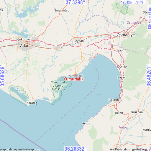
Yumurtalık GPS coordinates[2]
36° 46' 7.068" North, 35° 47' 21.768" East
| Map corner | latitude | longitude |
|---|---|---|
| Upper-left | 37.3298°, | 35.08626° |
| Center: | 36.76863°, | 35.78938° |
| Lower-right: | 36.20332°, | 36.49251° |
| Map W x H: | 125.3×125.3 km | = 77.9×77.9mi |
| max Lat: | 42.02683° ⇑93.7% North |
| Yumurtalık: | 36.76863° |
| min Lat: | ⇓6.3% South 35.9025° |
| min Long | Yumurtalık | max Long |
| 25.90902° | 35.78938° | 44.60099° |
| W 49.1%⇐ | ⇒50.9% E |
Elevation
Elevation of Yumurtalık is 19 m = 62 ft, and this is 698.4 m = 2291 ft below average elevation for this country.
| Max E: |
2682 m = 8799 ft | 94.3% |
| Avg. | 717.4 m = 2354 ft | |
| Yumurtalık | 19 m = 62 ft | |
Min E: |
0 m = 0 ft | 5.7% |
See also: Turkey elevation on elevation.city.
Geographical zone
Yumurtalık is located in North temperate zone (between Tropic of Cancer and the Arctic Circle). Distance of this Northern Tropic circle is 1482.4 km =921.1 mi to South.| Distance of | km | miles | from Yumurtalık |
|---|---|---|---|
| North Pole | 5918.8 | 3677.8 | to North |
| Arctic Circle | 3312.9 | 2058.5 | to North |
| Tropic Cancer | 1482.4 | 921.1 | to South |
| Equator | 4088.3 | 2540.4 | to South |


Nearby cities:
15 places around Yumurtalık: (largest is in red/bold)
• Arsuz
40.6 km =25.2 mi,  167°
167°
• Ceyhan
28.6 km =17.8 mi,  5°
5°
• Denizciler
40.4 km =25.1 mi,  110°
110°
• Doğankent
40.5 km =25.2 mi,  281°
281°
• Dörtyol
40 km =24.9 mi,  78°
78°
• Erzin
41.8 km =26 mi,  60°
60°
• Karataş
42.8 km =26.6 mi,  240°
240°
• Konaklı
44.4 km =27.6 mi, 84°
• Mahmutlar
41.1 km =25.5 mi, 60°
• Payas
37.9 km =23.5 mi,  92°
92°
• Toprakkale
46 km =28.6 mi,  43°
43°
• Yakapınar
27.3 km =17 mi,  326°
326°
• Yüreğir
44.6 km =27.7 mi,  300°
300°
• Çırtıman
44.2 km =27.5 mi,  127°
127°
• İskenderun
39.8 km =24.7 mi,  120°
120°
Sources, notices
• [Note1] Compared only with cities in Turkey existing in our database
• [Src1] Map data: © OpenStreetMap contributors (CC-BY-SA)
• [Src2] Other city data from geonames.org with taken over terms of usage.
• [Src3] Geographical zone / Annual Mean Temperature by Robert A. Rohde @ Wikipedia
