Ceyhan geodata
Ceyhan (Adana) is a seat of a second-order administrative division; located in Turkey in Europe/Istanbul (GMT+3) time zone. With population of 96,303 people, there are 87 cities with bigger population in this country. Compared to other cities in Turkey, 87.4% of cities are located further ↑North; 50.6% of cities are located further →East and 91.8% of cities have higher elevation than Ceyhan. Note1


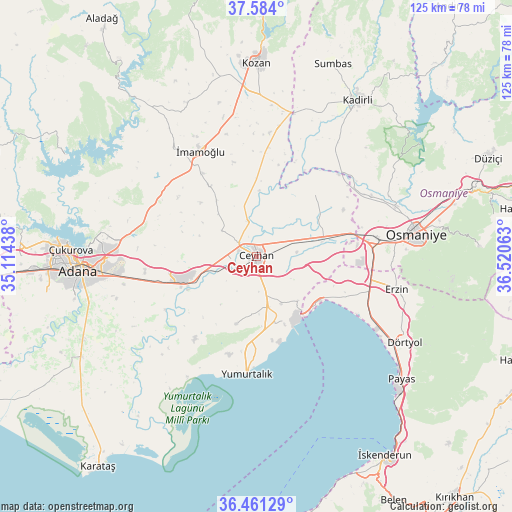
Ceyhan GPS coordinates[2]
37° 1' 28.992" North, 35° 49' 3" East
| Map corner | latitude | longitude |
|---|---|---|
| Upper-left | 37.584°, | 35.11438° |
| Center: | 37.02472°, | 35.8175° |
| Lower-right: | 36.46129°, | 36.52063° |
| Map W x H: | 124.8×124.8 km | = 77.5×77.5mi |
| max Lat: | 42.02683° ⇑87.4% North |
| Ceyhan: | 37.02472° |
| min Lat: | ⇓12.6% South 35.9025° |
| min Long | Ceyhan | max Long |
| 25.90902° | 35.8175° | 44.60099° |
| W 49.4%⇐ | ⇒50.6% E |
Elevation
Elevation of Ceyhan is 30 m = 98 ft, and this is 687.4 m = 2255 ft below average elevation for this country.
| Max E: |
2682 m = 8799 ft | 91.8% |
| Avg. | 717.4 m = 2354 ft | |
| Ceyhan | 30 m = 98 ft | |
Min E: |
0 m = 0 ft | 8.2% |
See also: Ceyhan elevation on elevation.city.
Geographical zone
Ceyhan is located in North temperate zone (between Tropic of Cancer and the Arctic Circle). Distance of this Northern Tropic circle is 1510.8 km =938.8 mi to South.| Distance of | km | miles | from Ceyhan |
|---|---|---|---|
| North Pole | 5890.3 | 3660.1 | to North |
| Arctic Circle | 3284.4 | 2040.8 | to North |
| Tropic Cancer | 1510.8 | 938.8 | to South |
| Equator | 4116.8 | 2558.1 | to South |


Nearby cities:
15 places around Ceyhan: (largest is in red/bold)
• Adana
43.5 km =27 mi,  266°
266°
• Dörtyol
42.1 km =26.2 mi,  119°
119°
• Erzin
34.7 km =21.6 mi,  103°
103°
• Kösreli
20.9 km =13 mi,  42°
42°
• Mahmutlar
34.3 km =21.3 mi, 104°
• Osmaniye
38.6 km =24 mi,  81°
81°
• Sarıçam
30.9 km =19.2 mi,  297°
297°
• Sağkaya
20.6 km =12.8 mi,  326°
326°
• Tecirli
30.1 km =18.7 mi,  59°
59°
• Tepecikören
41.1 km =25.5 mi,  335°
335°
• Toprakkale
29.6 km =18.4 mi, 80°
• Yakapınar
18.4 km =11.4 mi,  251°
251°
• Yumurtalık
28.6 km =17.8 mi,  185°
185°
• Yüreğir
41.1 km =25.5 mi,  262°
262°
• İmamoğlu
30.3 km =18.8 mi, 331°
Sources, notices
• [Note1] Compared only with cities in Turkey existing in our database
• [Src1] Map data: © OpenStreetMap contributors (CC-BY-SA)
• [Src2] Other city data from geonames.org with taken over terms of usage.
• [Src3] Geographical zone / Annual Mean Temperature by Robert A. Rohde @ Wikipedia
