Kürecik geodata
Kürecik (Kahramanmaraş) is a seat of a third-order administrative division; located in Turkey in Europe/Istanbul (GMT+3) time zone. In our database, there are 1323 cities with bigger population. Compared to other cities in Turkey, 55.4% of cities are located further ↑North; 60% of cities are located further ←West and 92.3% of cities have lower elevation than Kürecik. Note1


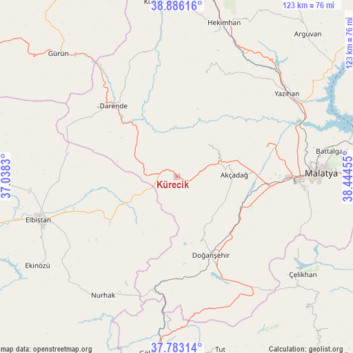
Kürecik GPS coordinates[2]
38° 20' 12.3" North, 37° 44' 29.112" East
| Map corner | latitude | longitude |
|---|---|---|
| Upper-left | 38.88616°, | 37.0383° |
| Center: | 38.33675°, | 37.74142° |
| Lower-right: | 37.78314°, | 38.44455° |
| Map W x H: | 122.6×122.6 km | = 76.2×76.2mi |
| max Lat: | 42.02683° ⇑55.4% North |
| Kürecik: | 38.33675° |
| min Lat: | ⇓44.6% South 35.9025° |
| min Long | Kürecik | max Long |
| 25.90902° | 37.74142° | 44.60099° |
| W 60%⇐ | ⇒40% E |
Elevation
Elevation of Kürecik is 1548 m = 5079 ft, and this is 830.6 m = 2725 ft above average elevation for this country.
| Max E: |
2682 m = 8799 ft | 7.7% |
| Kürecik | 1548 m 5079 ft | |
| Avg. | 717.4 m = 2354 ft | |
Min E: |
0 m = 0 ft | 92.3% |
See also: Turkey elevation on elevation.city.
Geographical zone
Kürecik is located in North temperate zone (between Tropic of Cancer and the Arctic Circle). Distance of this Northern Tropic circle is 1656.7 km =1029.4 mi to South.| Distance of | km | miles | from Kürecik |
|---|---|---|---|
| North Pole | 5744.4 | 3569.4 | to North |
| Arctic Circle | 3138.5 | 1950.2 | to North |
| Tropic Cancer | 1656.7 | 1029.4 | to South |
| Equator | 4262.6 | 2648.7 | to South |


Nearby cities:
15 places around Kürecik: (largest is in red/bold)
• Akçadağ
20 km =12.4 mi,  89°
89°
• Balaban
19.8 km =12.3 mi,  314°
314°
• Battalgazi
54.6 km =33.9 mi,  79°
79°
• Darende
31 km =19.3 mi,  318°
318°
• Doğanşehir
30.1 km =18.7 mi,  157°
157°
• Elbistan
49.6 km =30.8 mi,  252°
252°
• Gücük
27.7 km =17.2 mi,  234°
234°
• Kurşunlu
36.5 km =22.7 mi,  15°
15°
• Levent
14.9 km =9.3 mi,  41°
41°
• Malatya
50.2 km =31.2 mi, 88°
• Nurhak
49.1 km =30.5 mi,  212°
212°
• Sürgü
41.6 km =25.8 mi,  152°
152°
• Yazıhan
47.2 km =29.3 mi,  52°
52°
• Yeşilyurt
44.2 km =27.5 mi,  95°
95°
• Çelikhan
55.4 km =34.4 mi,  128°
128°
Sources, notices
• [Note1] Compared only with cities in Turkey existing in our database
• [Src1] Map data: © OpenStreetMap contributors (CC-BY-SA)
• [Src2] Other city data from geonames.org with taken over terms of usage.
• [Src3] Geographical zone / Annual Mean Temperature by Robert A. Rohde @ Wikipedia
