Sincik geodata
Sincik (Adıyaman) is a seat of a second-order administrative division; located in Turkey in Europe/Istanbul (GMT+3) time zone. With population of 7,152 people, there are 611 cities with bigger population in this country. Compared to other cities in Turkey, 60.8% of cities are located further ↑North; 64.7% of cities are located further ←West and 83.1% of cities have lower elevation than Sincik. Note1


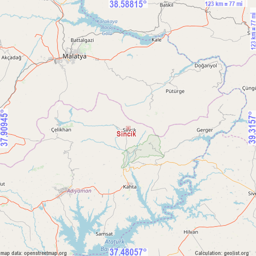
Sincik GPS coordinates[2]
38° 2' 11.22" North, 38° 36' 45.252" East
| Map corner | latitude | longitude |
|---|---|---|
| Upper-left | 38.58815°, | 37.90945° |
| Center: | 38.03645°, | 38.61257° |
| Lower-right: | 37.48057°, | 39.3157° |
| Map W x H: | 123.2×123.2 km | = 76.6×76.6mi |
| max Lat: | 42.02683° ⇑60.8% North |
| Sincik: | 38.03645° |
| min Lat: | ⇓39.2% South 35.9025° |
| min Long | Sincik | max Long |
| 25.90902° | 38.61257° | 44.60099° |
| W 64.7%⇐ | ⇒35.3% E |
Elevation
Elevation of Sincik is 1266 m = 4154 ft, and this is 548.6 m = 1800 ft above average elevation for this country.
| Max E: |
2682 m = 8799 ft | 16.9% |
| Sincik | 1266 m 4154 ft | |
| Avg. | 717.4 m = 2354 ft | |
Min E: |
0 m = 0 ft | 83.1% |
See also: Turkey elevation on elevation.city.
Geographical zone
Sincik is located in North temperate zone (between Tropic of Cancer and the Arctic Circle). Distance of this Northern Tropic circle is 1623.3 km =1008.7 mi to South.| Distance of | km | miles | from Sincik |
|---|---|---|---|
| North Pole | 5777.8 | 3590.2 | to North |
| Arctic Circle | 3171.9 | 1970.9 | to North |
| Tropic Cancer | 1623.3 | 1008.7 | to South |
| Equator | 4229.3 | 2628 | to South |


Nearby cities:
15 places around Sincik: (largest is in red/bold)
• Adıyaman
42.3 km =26.3 mi,  224°
224°
• Akıncılar
35.4 km =22 mi,  148°
148°
• Damlacık
14.1 km =8.8 mi,  165°
165°
• Gerger
36.7 km =22.8 mi,  105°
105°
• Gerger
36.9 km =22.9 mi,  91°
91°
• Koçali
33.5 km =20.8 mi,  247°
247°
• Kuyucak
30.5 km =19 mi,  230°
230°
• Kâhta
27.9 km =17.3 mi,  177°
177°
• Narince
21.4 km =13.3 mi,  143°
143°
• Pütürge
28.4 km =17.6 mi,  50°
50°
• Taraksu
41.3 km =25.7 mi, 93°
• Tepehan
13.5 km =8.4 mi, 47°
• Yarpuzlu
8.2 km =5.1 mi,  283°
283°
• Çelikhan
32.9 km =20.4 mi,  267°
267°
• Çolaklı
34 km =21.1 mi,  346°
346°
Sources, notices
• [Note1] Compared only with cities in Turkey existing in our database
• [Src1] Map data: © OpenStreetMap contributors (CC-BY-SA)
• [Src2] Other city data from geonames.org with taken over terms of usage.
• [Src3] Geographical zone / Annual Mean Temperature by Robert A. Rohde @ Wikipedia
