Derinkuyu geodata
Derinkuyu (Nevşehir) is a seat of a second-order administrative division; located in Turkey in Europe/Istanbul (GMT+3) time zone. With population of 12,408 people, there are 442 cities with bigger population in this country. Compared to other cities in Turkey, 54.8% of cities are located further ↑North; 55.6% of cities are located further →East and 86.4% of cities have lower elevation than Derinkuyu. Note1


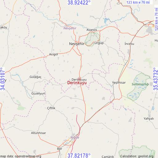
Derinkuyu GPS coordinates[2]
38° 22' 30.36" North, 34° 44' 3.084" East
| Map corner | latitude | longitude |
|---|---|---|
| Upper-left | 38.92422°, | 34.03107° |
| Center: | 38.3751°, | 34.73419° |
| Lower-right: | 37.82178°, | 35.43732° |
| Map W x H: | 122.6×122.6 km | = 76.2×76.2mi |
| max Lat: | 42.02683° ⇑54.8% North |
| Derinkuyu: | 38.3751° |
| min Lat: | ⇓45.2% South 35.9025° |
| min Long | Derinkuyu | max Long |
| 25.90902° | 34.73419° | 44.60099° |
| W 44.4%⇐ | ⇒55.6% E |
Elevation
Elevation of Derinkuyu is 1354 m = 4442 ft, and this is 636.6 m = 2089 ft above average elevation for this country.
| Max E: |
2682 m = 8799 ft | 13.6% |
| Derinkuyu | 1354 m 4442 ft | |
| Avg. | 717.4 m = 2354 ft | |
Min E: |
0 m = 0 ft | 86.4% |
See also: Turkey elevation on elevation.city.
Geographical zone
Derinkuyu is located in North temperate zone (between Tropic of Cancer and the Arctic Circle). Distance of this Northern Tropic circle is 1661 km =1032.1 mi to South.| Distance of | km | miles | from Derinkuyu |
|---|---|---|---|
| North Pole | 5740.2 | 3566.8 | to North |
| Arctic Circle | 3134.3 | 1947.6 | to North |
| Tropic Cancer | 1661 | 1032.1 | to South |
| Equator | 4266.9 | 2651.3 | to South |


Nearby cities:
15 places around Derinkuyu: (largest is in red/bold)
• Acıgöl
27.6 km =17.1 mi,  314°
314°
• Altunhisar
53 km =32.9 mi,  216°
216°
• Avanos
39 km =24.2 mi,  14°
14°
• Göreme
31.1 km =19.3 mi,  16°
16°
• Gülağaç
33.9 km =21.1 mi,  273°
273°
• Gülşehir
42.3 km =26.3 mi,  347°
347°
• Güzelyurt
33.4 km =20.8 mi,  250°
250°
• Misli
16.4 km =10.2 mi,  166°
166°
• Nevşehir
27.9 km =17.3 mi,  356°
356°
• Niğde
45.8 km =28.5 mi,  186°
186°
• Yeşilhisar
31 km =19.3 mi,  94°
94°
• Çiftlik
31 km =19.3 mi, 224°
• Özonak
49.5 km =30.8 mi, 10°
• Ürgüp
32.3 km =20.1 mi,  28°
28°
• İncesu
47.7 km =29.6 mi,  54°
54°
Sources, notices
• [Note1] Compared only with cities in Turkey existing in our database
• [Src1] Map data: © OpenStreetMap contributors (CC-BY-SA)
• [Src2] Other city data from geonames.org with taken over terms of usage.
• [Src3] Geographical zone / Annual Mean Temperature by Robert A. Rohde @ Wikipedia
