Acıgöl geodata
Acıgöl (Nevşehir) is a seat of a second-order administrative division; located in Turkey in Europe/Istanbul (GMT+3) time zone. With population of 6,749 people, there are 623 cities with bigger population in this country. Compared to other cities in Turkey, 52.3% of cities are located further ↑North; 56.4% of cities are located further →East and 82.4% of cities have lower elevation than Acıgöl. Note1


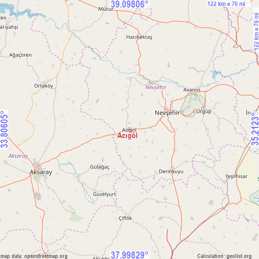
Acıgöl GPS coordinates[2]
38° 33' 1.008" North, 34° 30' 33.012" East
| Map corner | latitude | longitude |
|---|---|---|
| Upper-left | 39.09806°, | 33.80605° |
| Center: | 38.55028°, | 34.50917° |
| Lower-right: | 37.99829°, | 35.2123° |
| Map W x H: | 122.3×122.3 km | = 76×76mi |
| max Lat: | 42.02683° ⇑52.3% North |
| Acıgöl: | 38.55028° |
| min Lat: | ⇓47.7% South 35.9025° |
| min Long | Acıgöl | max Long |
| 25.90902° | 34.50917° | 44.60099° |
| W 43.6%⇐ | ⇒56.4% E |
Elevation
Elevation of Acıgöl is 1246 m = 4088 ft, and this is 528.6 m = 1734 ft above average elevation for this country.
| Max E: |
2682 m = 8799 ft | 17.6% |
| Acıgöl | 1246 m 4088 ft | |
| Avg. | 717.4 m = 2354 ft | |
Min E: |
0 m = 0 ft | 82.4% |
See also: Turkey elevation on elevation.city.
Geographical zone
Acıgöl is located in North temperate zone (between Tropic of Cancer and the Arctic Circle). Distance of this Northern Tropic circle is 1680.5 km =1044.2 mi to South.| Distance of | km | miles | from Acıgöl |
|---|---|---|---|
| North Pole | 5720.7 | 3554.7 | to North |
| Arctic Circle | 3114.8 | 1935.4 | to North |
| Tropic Cancer | 1680.5 | 1044.2 | to South |
| Equator | 4286.4 | 2663.4 | to South |


Nearby cities:
15 places around Acıgöl: (largest is in red/bold)
• Avanos
34.6 km =21.5 mi,  58°
58°
• Balcı
40.4 km =25.1 mi,  298°
298°
• Derinkuyu
27.6 km =17.1 mi,  134°
134°
• Göreme
30.2 km =18.8 mi,  69°
69°
• Gülağaç
22.3 km =13.9 mi,  219°
219°
• Gülşehir
24 km =14.9 mi,  24°
24°
• Güzelyurt
32.6 km =20.3 mi,  201°
201°
• Hacıbektaş
43.6 km =27.1 mi,  5°
5°
• Misli
42.5 km =26.4 mi,  146°
146°
• Nevşehir
19.5 km =12.1 mi, 64°
• Ortaköy
45.8 km =28.5 mi, 296°
• Salanda
30.7 km =19.1 mi,  3°
3°
• Çiftlik
41.7 km =25.9 mi,  182°
182°
• Özonak
41 km =25.5 mi,  44°
44°
• Ürgüp
36.1 km =22.4 mi,  75°
75°
Sources, notices
• [Note1] Compared only with cities in Turkey existing in our database
• [Src1] Map data: © OpenStreetMap contributors (CC-BY-SA)
• [Src2] Other city data from geonames.org with taken over terms of usage.
• [Src3] Geographical zone / Annual Mean Temperature by Robert A. Rohde @ Wikipedia
