Sivrihisar geodata
Sivrihisar (Eskişehir) is a seat of a second-order administrative division; located in Turkey in Europe/Istanbul (GMT+3) time zone. With population of 10,535 people, there are 495 cities with bigger population in this country. Compared to other cities in Turkey, 60.7% of cities are located further ↓South; 68.7% of cities are located further →East and 74% of cities have lower elevation than Sivrihisar. Note1


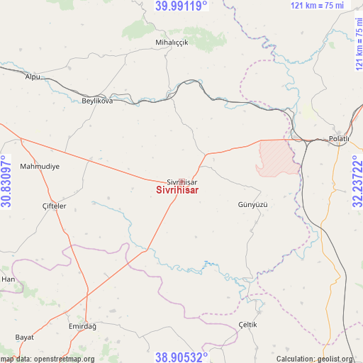
Sivrihisar GPS coordinates[2]
39° 27' 1.332" North, 31° 32' 2.724" East
| Map corner | latitude | longitude |
|---|---|---|
| Upper-left | 39.99119°, | 30.83097° |
| Center: | 39.45037°, | 31.53409° |
| Lower-right: | 38.90532°, | 32.23722° |
| Map W x H: | 120.7×120.7 km | = 75×75mi |
| max Lat: | 42.02683° ⇑39.3% North |
| Sivrihisar: | 39.45037° |
| min Lat: | ⇓60.7% South 35.9025° |
| min Long | Sivrihisar | max Long |
| 25.90902° | 31.53409° | 44.60099° |
| W 31.3%⇐ | ⇒68.7% E |
Elevation
Elevation of Sivrihisar is 1090 m = 3576 ft, and this is 372.6 m = 1222 ft above average elevation for this country.
| Max E: |
2682 m = 8799 ft | 26% |
| Sivrihisar | 1090 m 3576 ft | |
| Avg. | 717.4 m = 2354 ft | |
Min E: |
0 m = 0 ft | 74% |
See also: Turkey elevation on elevation.city.
Geographical zone
Sivrihisar is located in North temperate zone (between Tropic of Cancer and the Arctic Circle). Distance of this Northern Tropic circle is 1780.6 km =1106.4 mi to South.| Distance of | km | miles | from Sivrihisar |
|---|---|---|---|
| North Pole | 5620.6 | 3492.5 | to North |
| Arctic Circle | 3014.7 | 1873.2 | to North |
| Tropic Cancer | 1780.6 | 1106.4 | to South |
| Equator | 4386.5 | 2725.6 | to South |


Nearby cities:
15 places around Sivrihisar: (largest is in red/bold)
• Alpu
60.6 km =37.7 mi,  305°
305°
• Beylikova
38.5 km =23.9 mi, 313°
• Bozan
52.7 km =32.7 mi,  315°
315°
• Davulga
54.2 km =33.7 mi,  194°
194°
• Emirdağ
58.2 km =36.2 mi,  214°
214°
• Günyüzü
24.8 km =15.4 mi,  107°
107°
• Han
66.3 km =41.2 mi,  240°
240°
• Kaymaz
31.3 km =19.4 mi,  283°
283°
• Mahmudiye
47.2 km =29.3 mi, 276°
• Mihalıçcık
46.3 km =28.8 mi,  355°
355°
• Polatlı
54 km =33.6 mi,  74°
74°
• Umraniye
40 km =24.9 mi,  220°
220°
• Yenimehmetli
54.6 km =33.9 mi,  93°
93°
• Çeltik
52.3 km =32.5 mi,  154°
154°
• Çifteler
43.2 km =26.8 mi,  260°
260°
Sources, notices
• [Note1] Compared only with cities in Turkey existing in our database
• [Src1] Map data: © OpenStreetMap contributors (CC-BY-SA)
• [Src2] Other city data from geonames.org with taken over terms of usage.
• [Src3] Geographical zone / Annual Mean Temperature by Robert A. Rohde @ Wikipedia
