Finike geodata
Finike (Antalya) is a seat of a second-order administrative division; located in Turkey in Europe/Istanbul (GMT+3) time zone. With population of 9,250 people, there are 526 cities with bigger population in this country. Compared to other cities in Turkey, 97.8% of cities are located further ↑North; 75.2% of cities are located further →East and 88.4% of cities have higher elevation than Finike. Note1


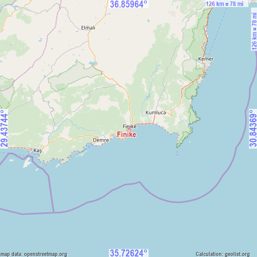
Finike GPS coordinates[2]
36° 17' 42" North, 30° 8' 26.016" East
| Map corner | latitude | longitude |
|---|---|---|
| Upper-left | 36.85964°, | 29.43744° |
| Center: | 36.295°, | 30.14056° |
| Lower-right: | 35.72624°, | 30.84369° |
| Map W x H: | 126×126 km | = 78.3×78.3mi |
| max Lat: | 42.02683° ⇑97.8% North |
| Finike: | 36.295° |
| min Lat: | ⇓2.2% South 35.9025° |
| min Long | Finike | max Long |
| 25.90902° | 30.14056° | 44.60099° |
| W 24.8%⇐ | ⇒75.2% E |
Elevation
Elevation of Finike is 48 m = 157 ft, and this is 669.4 m = 2196 ft below average elevation for this country.
| Max E: |
2682 m = 8799 ft | 88.4% |
| Avg. | 717.4 m = 2354 ft | |
| Finike | 48 m = 157 ft | |
Min E: |
0 m = 0 ft | 11.6% |
See also: Turkey elevation on elevation.city.
Geographical zone
Finike is located in North temperate zone (between Tropic of Cancer and the Arctic Circle). Distance of this Northern Tropic circle is 1429.7 km =888.4 mi to South.| Distance of | km | miles | from Finike |
|---|---|---|---|
| North Pole | 5971.4 | 3710.5 | to North |
| Arctic Circle | 3365.5 | 2091.2 | to North |
| Tropic Cancer | 1429.7 | 888.4 | to South |
| Equator | 4035.6 | 2507.6 | to South |


Nearby cities:
15 places around Finike: (largest is in red/bold)
• Akçay
49.1 km =30.5 mi,  314°
314°
• Altınyaka
34.7 km =21.6 mi,  32°
32°
• Beykonak
15 km =9.3 mi,  76°
76°
• Demre
15 km =9.3 mi,  248°
248°
• Elmalı
52.9 km =32.9 mi,  337°
337°
• Geyikbayırı
70.5 km =43.8 mi,  23°
23°
• Gölova
56.8 km =35.3 mi,  350°
350°
• Göynük
54.7 km =34 mi,  42°
42°
• Kalkan
65.2 km =40.5 mi,  267°
267°
• Kaş
46.3 km =28.8 mi,  257°
257°
• Kemer
50.4 km =31.3 mi,  48°
48°
• Kumluca
15.6 km =9.7 mi,  57°
57°
• Seki
71.5 km =44.4 mi,  322°
322°
• Tekirova
41.5 km =25.8 mi, 56°
• Turunçova
8.2 km =5.1 mi,  358°
358°
Sources, notices
• [Note1] Compared only with cities in Turkey existing in our database
• [Src1] Map data: © OpenStreetMap contributors (CC-BY-SA)
• [Src2] Other city data from geonames.org with taken over terms of usage.
• [Src3] Geographical zone / Annual Mean Temperature by Robert A. Rohde @ Wikipedia
