Pazarören geodata
Pazarören (Kayseri) is a seat of a third-order administrative division; located in Turkey in Europe/Istanbul (GMT+3) time zone. In our database, there are 1323 cities with bigger population. Compared to other cities in Turkey, 50.3% of cities are located further ↑North; 51.8% of cities are located further ←West and 91.6% of cities have lower elevation than Pazarören. Note1


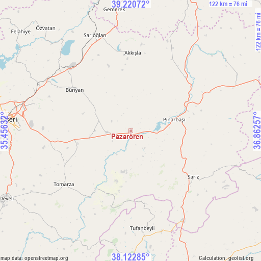
Pazarören GPS coordinates[2]
38° 40' 26.004" North, 36° 9' 33.984" East
| Map corner | latitude | longitude |
|---|---|---|
| Upper-left | 39.22072°, | 35.45632° |
| Center: | 38.67389°, | 36.15944° |
| Lower-right: | 38.12285°, | 36.86257° |
| Map W x H: | 122.1×122.1 km | = 75.9×75.9mi |
| max Lat: | 42.02683° ⇑50.3% North |
| Pazarören: | 38.67389° |
| min Lat: | ⇓49.7% South 35.9025° |
| min Long | Pazarören | max Long |
| 25.90902° | 36.15944° | 44.60099° |
| W 51.8%⇐ | ⇒48.2% E |
Elevation
Elevation of Pazarören is 1526 m = 5007 ft, and this is 808.6 m = 2653 ft above average elevation for this country.
| Max E: |
2682 m = 8799 ft | 8.4% |
| Pazarören | 1526 m 5007 ft | |
| Avg. | 717.4 m = 2354 ft | |
Min E: |
0 m = 0 ft | 91.6% |
See also: Turkey elevation on elevation.city.
Geographical zone
Pazarören is located in North temperate zone (between Tropic of Cancer and the Arctic Circle). Distance of this Northern Tropic circle is 1694.2 km =1052.7 mi to South.| Distance of | km | miles | from Pazarören |
|---|---|---|---|
| North Pole | 5706.9 | 3546.1 | to North |
| Arctic Circle | 3101 | 1926.9 | to North |
| Tropic Cancer | 1694.2 | 1052.7 | to South |
| Equator | 4300.1 | 2672 | to South |


Nearby cities:
15 places around Pazarören: (largest is in red/bold)
• Akkışla
36.5 km =22.7 mi,  1°
1°
• Bünyan
32.2 km =20 mi,  306°
306°
• Elbaşı
16.7 km =10.4 mi,  269°
269°
• Gesi
45.3 km =28.1 mi,  286°
286°
• Kaynar
35.8 km =22.2 mi,  45°
45°
• Kocasinan
52.1 km =32.4 mi,  282°
282°
• Muncusun
52.7 km =32.7 mi,  298°
298°
• Pınarbaşı
21 km =13 mi,  74°
74°
• Sarıoğlan
47.8 km =29.7 mi,  339°
339°
• Sarız
36.6 km =22.7 mi,  126°
126°
• Talas
52.6 km =32.7 mi, 272°
• Toklar
31.1 km =19.3 mi,  203°
203°
• Tomarza
40.2 km =25 mi,  231°
231°
• Tufanbeyli
46 km =28.6 mi,  173°
173°
• Örenşehir
55.7 km =34.6 mi, 49°
Sources, notices
• [Note1] Compared only with cities in Turkey existing in our database
• [Src1] Map data: © OpenStreetMap contributors (CC-BY-SA)
• [Src2] Other city data from geonames.org with taken over terms of usage.
• [Src3] Geographical zone / Annual Mean Temperature by Robert A. Rohde @ Wikipedia
