Pınarbaşı geodata
Pınarbaşı (Kayseri) is a seat of a second-order administrative division; located in Turkey in Europe/Istanbul (GMT+3) time zone. With population of 12,333 people, there are 444 cities with bigger population in this country. Compared to other cities in Turkey, 50.4% of cities are located further ↓South; 54% of cities are located further ←West and 91.1% of cities have lower elevation than Pınarbaşı. Note1


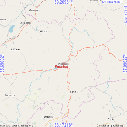
Pınarbaşı GPS coordinates[2]
38° 43' 22.26" North, 36° 23' 35.304" East
| Map corner | latitude | longitude |
|---|---|---|
| Upper-left | 39.26931°, | 35.69002° |
| Center: | 38.72285°, | 36.39314° |
| Lower-right: | 38.17218°, | 37.09627° |
| Map W x H: | 122×122 km | = 75.8×75.8mi |
| max Lat: | 42.02683° ⇑49.6% North |
| Pınarbaşı: | 38.72285° |
| min Lat: | ⇓50.4% South 35.9025° |
| min Long | Pınarbaşı | max Long |
| 25.90902° | 36.39314° | 44.60099° |
| W 54%⇐ | ⇒46% E |
Elevation
Elevation of Pınarbaşı is 1509 m = 4951 ft, and this is 791.6 m = 2597 ft above average elevation for this country.
| Max E: |
2682 m = 8799 ft | 8.9% |
| Pınarbaşı | 1509 m 4951 ft | |
| Avg. | 717.4 m = 2354 ft | |
Min E: |
0 m = 0 ft | 91.1% |
See also: Turkey elevation on elevation.city.
Geographical zone
Pınarbaşı is located in North temperate zone (between Tropic of Cancer and the Arctic Circle). Distance of this Northern Tropic circle is 1699.7 km =1056.1 mi to South.| Distance of | km | miles | from Pınarbaşı |
|---|---|---|---|
| North Pole | 5701.5 | 3542.7 | to North |
| Arctic Circle | 3095.6 | 1923.5 | to North |
| Tropic Cancer | 1699.7 | 1056.1 | to South |
| Equator | 4305.6 | 2675.4 | to South |


Nearby cities:
15 places around Pınarbaşı: (largest is in red/bold)
• Akkışla
36.4 km =22.6 mi,  328°
328°
• Bünyan
48.2 km =30 mi,  286°
286°
• Elbaşı
37.3 km =23.2 mi,  261°
261°
• Gemerek
58.3 km =36.2 mi, 331°
• Gesi
64.1 km =39.8 mi,  276°
276°
• Kaynar
20.3 km =12.6 mi,  15°
15°
• Pazarören
21 km =13 mi,  254°
254°
• Sarıoğlan
54 km =33.6 mi,  316°
316°
• Sarız
28.6 km =17.8 mi,  161°
161°
• Tanır
56.3 km =35 mi,  126°
126°
• Toklar
47.2 km =29.3 mi,  224°
224°
• Tomarza
60 km =37.3 mi,  239°
239°
• Tufanbeyli
53.3 km =33.1 mi,  196°
196°
• Yazyurdu
47.5 km =29.5 mi,  79°
79°
• Örenşehir
37.8 km =23.5 mi,  35°
35°
Sources, notices
• [Note1] Compared only with cities in Turkey existing in our database
• [Src1] Map data: © OpenStreetMap contributors (CC-BY-SA)
• [Src2] Other city data from geonames.org with taken over terms of usage.
• [Src3] Geographical zone / Annual Mean Temperature by Robert A. Rohde @ Wikipedia
