Tercan geodata
Tercan (Erzincan) is a seat of a second-order administrative division; located in Turkey in Europe/Istanbul (GMT+3) time zone. With population of 12,235 people, there are 446 cities with bigger population in this country. Compared to other cities in Turkey, 65.2% of cities are located further ↓South; 75.7% of cities are located further ←West and 88.4% of cities have lower elevation than Tercan. Note1


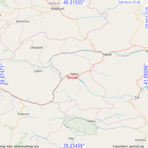
Tercan GPS coordinates[2]
39° 46' 37.524" North, 40° 22' 40.188" East
| Map corner | latitude | longitude |
|---|---|---|
| Upper-left | 40.31535°, | 39.67471° |
| Center: | 39.77709°, | 40.37783° |
| Lower-right: | 39.23459°, | 41.08096° |
| Map W x H: | 120.2×120.2 km | = 74.7×74.7mi |
| max Lat: | 42.02683° ⇑34.8% North |
| Tercan: | 39.77709° |
| min Lat: | ⇓65.2% South 35.9025° |
| min Long | Tercan | max Long |
| 25.90902° | 40.37783° | 44.60099° |
| W 75.7%⇐ | ⇒24.3% E |
Elevation
Elevation of Tercan is 1412 m = 4633 ft, and this is 694.6 m = 2279 ft above average elevation for this country.
| Max E: |
2682 m = 8799 ft | 11.6% |
| Tercan | 1412 m 4633 ft | |
| Avg. | 717.4 m = 2354 ft | |
Min E: |
0 m = 0 ft | 88.4% |
See also: Turkey elevation on elevation.city.
Geographical zone
Tercan is located in North temperate zone (between Tropic of Cancer and the Arctic Circle). Distance of this Northern Tropic circle is 1816.9 km =1129 mi to South.| Distance of | km | miles | from Tercan |
|---|---|---|---|
| North Pole | 5584.3 | 3469.9 | to North |
| Arctic Circle | 2978.4 | 1850.7 | to North |
| Tropic Cancer | 1816.9 | 1129 | to South |
| Equator | 4422.8 | 2748.2 | to South |


Nearby cities:
15 places around Tercan: (largest is in red/bold)
• Aşkale
31.4 km =19.5 mi,  59°
59°
• Balpayam
48.3 km =30 mi,  214°
214°
• Başköy
47 km =29.2 mi,  283°
283°
• Dağyolu
48.2 km =30 mi,  236°
236°
• Kandilli
41.7 km =25.9 mi,  69°
69°
• Kasaba
51.6 km =32.1 mi,  182°
182°
• Maden
45 km =28 mi,  2°
2°
• Otlukbeli
37.4 km =23.2 mi,  304°
304°
• Pulumer
52.6 km =32.7 mi,  231°
231°
• Tanyeri
50.2 km =31.2 mi,  248°
248°
• Yedisu
40.5 km =25.2 mi,  160°
160°
• Çat
54 km =33.6 mi,  110°
110°
• Çayırlı
30.1 km =18.7 mi, 276°
• Çiftlik
22 km =13.7 mi,  88°
88°
• Üçdam
29.4 km =18.3 mi,  216°
216°
Sources, notices
• [Note1] Compared only with cities in Turkey existing in our database
• [Src1] Map data: © OpenStreetMap contributors (CC-BY-SA)
• [Src2] Other city data from geonames.org with taken over terms of usage.
• [Src3] Geographical zone / Annual Mean Temperature by Robert A. Rohde @ Wikipedia
