Aşkale geodata
Aşkale (Erzurum) is a populated place; located in Turkey in Europe/Istanbul (GMT+3) time zone. With population of 15,462 people, there are 384 cities with bigger population in this country. Compared to other cities in Turkey, 68% of cities are located further ↓South; 78.4% of cities are located further ←West and 94.5% of cities have lower elevation than Aşkale. Note1


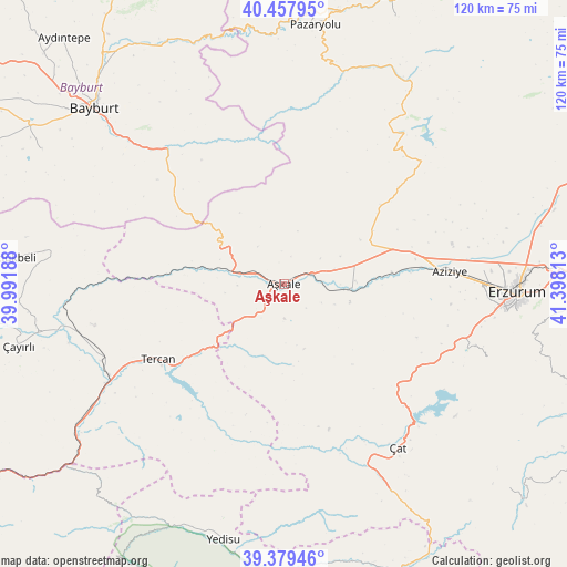
Aşkale GPS coordinates[2]
39° 55' 14.988" North, 40° 41' 42" East
| Map corner | latitude | longitude |
|---|---|---|
| Upper-left | 40.45795°, | 39.99188° |
| Center: | 39.92083°, | 40.695° |
| Lower-right: | 39.37946°, | 41.39813° |
| Map W x H: | 119.9×119.9 km | = 74.5×74.5mi |
| max Lat: | 42.02683° ⇑32% North |
| Aşkale: | 39.92083° |
| min Lat: | ⇓68% South 35.9025° |
| min Long | Aşkale | max Long |
| 25.90902° | 40.695° | 44.60099° |
| W 78.4%⇐ | ⇒21.6% E |
Elevation
Elevation of Aşkale is 1659 m = 5443 ft, and this is 941.6 m = 3089 ft above average elevation for this country.
| Max E: |
2682 m = 8799 ft | 5.5% |
| Aşkale | 1659 m 5443 ft | |
| Avg. | 717.4 m = 2354 ft | |
Min E: |
0 m = 0 ft | 94.5% |
See also: Turkey elevation on elevation.city.
Geographical zone
Aşkale is located in North temperate zone (between Tropic of Cancer and the Arctic Circle). Distance of this Northern Tropic circle is 1832.9 km =1138.9 mi to South.| Distance of | km | miles | from Aşkale |
|---|---|---|---|
| North Pole | 5568.3 | 3460 | to North |
| Arctic Circle | 2962.4 | 1840.7 | to North |
| Tropic Cancer | 1832.9 | 1138.9 | to South |
| Equator | 4438.8 | 2758.1 | to South |


Nearby cities:
15 places around Aşkale: (largest is in red/bold)
• Bayburt
54.8 km =34.1 mi,  312°
312°
• Dadaşköy
47.8 km =29.7 mi,  86°
86°
• Erzurum
49.6 km =30.8 mi, 91°
• Ilıca
34.2 km =21.3 mi, 85°
• Kandilli
12.2 km =7.6 mi,  97°
97°
• Kazımkarabekir
50 km =31.1 mi, 90°
• Kırık
49.1 km =30.5 mi,  22°
22°
• Maden
38.1 km =23.7 mi,  319°
319°
• Ovacık
40.4 km =25.1 mi,  39°
39°
• Palandöken
50.1 km =31.1 mi, 94°
• Pazaryolu
54.9 km =34.1 mi,  6°
6°
• Tercan
31.4 km =19.5 mi,  239°
239°
• Yakutiye
49 km =30.4 mi, 92°
• Çat
42.1 km =26.2 mi,  146°
146°
• Çiftlik
16.2 km =10.1 mi,  198°
198°
Sources, notices
• [Note1] Compared only with cities in Turkey existing in our database
• [Src1] Map data: © OpenStreetMap contributors (CC-BY-SA)
• [Src2] Other city data from geonames.org with taken over terms of usage.
• [Src3] Geographical zone / Annual Mean Temperature by Robert A. Rohde @ Wikipedia
