Taşlı geodata
Taşlı (Siirt) is a populated place; located in Turkey in Europe/Istanbul (GMT+3) time zone. With population of 1,029 people, there are 1082 cities with bigger population in this country. Compared to other cities in Turkey, 61.7% of cities are located further ↑North; 91.5% of cities are located further ←West and 59.3% of cities have lower elevation than Taşlı. Note1


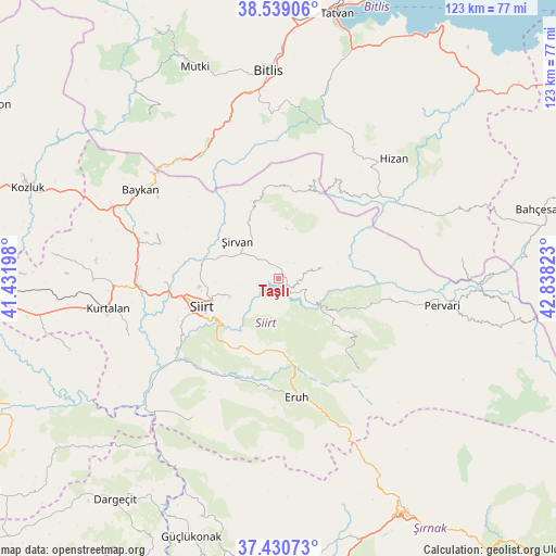
Taşlı GPS coordinates[2]
37° 59' 13.164" North, 42° 8' 6.36" East
| Map corner | latitude | longitude |
|---|---|---|
| Upper-left | 38.53906°, | 41.43198° |
| Center: | 37.98699°, | 42.1351° |
| Lower-right: | 37.43073°, | 42.83823° |
| Map W x H: | 123.2×123.2 km | = 76.6×76.6mi |
| max Lat: | 42.02683° ⇑61.7% North |
| Taşlı: | 37.98699° |
| min Lat: | ⇓38.3% South 35.9025° |
| min Long | Taşlı | max Long |
| 25.90902° | 42.1351° | 44.60099° |
| W 91.5%⇐ | ⇒8.5% E |
Elevation
Elevation of Taşlı is 870 m = 2854 ft, and this is 152.6 m = 501 ft above average elevation for this country.
| Max E: |
2682 m = 8799 ft | 40.7% |
| Taşlı | 870 m 2854 ft | |
| Avg. | 717.4 m = 2354 ft | |
Min E: |
0 m = 0 ft | 59.3% |
See also: Turkey elevation on elevation.city.
Geographical zone
Taşlı is located in North temperate zone (between Tropic of Cancer and the Arctic Circle). Distance of this Northern Tropic circle is 1617.8 km =1005.3 mi to South.| Distance of | km | miles | from Taşlı |
|---|---|---|---|
| North Pole | 5783.3 | 3593.6 | to North |
| Arctic Circle | 3177.4 | 1974.3 | to North |
| Tropic Cancer | 1617.8 | 1005.3 | to South |
| Equator | 4223.8 | 2624.5 | to South |


Nearby cities:
15 places around Taşlı: (largest is in red/bold)
• Cevizlik
22.4 km =13.9 mi,  20°
20°
• Civankan
24.4 km =15.2 mi,  247°
247°
• Doluharman
19.2 km =11.9 mi,  269°
269°
• Durankaya
4 km =2.5 mi,  91°
91°
• Ekmekçiler
11.3 km =7 mi,  183°
183°
• Gölgelikonak
24.2 km =15 mi, 181°
• Karasungur
21.3 km =13.2 mi,  122°
122°
• Meydandere
7.6 km =4.7 mi,  206°
206°
• Palamutlu
11.7 km =7.3 mi,  149°
149°
• Siirt
18.2 km =11.3 mi, 249°
• Taşdibek
14.6 km =9.1 mi,  106°
106°
• Tillo
11.6 km =7.2 mi, 248°
• Özpınar
9.7 km =6 mi,  78°
78°
• İkizbağlar
14.2 km =8.8 mi, 266°
• Şirvan
12.8 km =8 mi,  311°
311°
Sources, notices
• [Note1] Compared only with cities in Turkey existing in our database
• [Src1] Map data: © OpenStreetMap contributors (CC-BY-SA)
• [Src2] Other city data from geonames.org with taken over terms of usage.
• [Src3] Geographical zone / Annual Mean Temperature by Robert A. Rohde @ Wikipedia
