İkizbağlar geodata
İkizbağlar (Siirt) is a populated place; located in Turkey in Europe/Istanbul (GMT+3) time zone. With population of 688 people, there are 1203 cities with bigger population in this country. Compared to other cities in Turkey, 62% of cities are located further ↑North; 90.2% of cities are located further ←West and 73.4% of cities have lower elevation than İkizbağlar. Note1


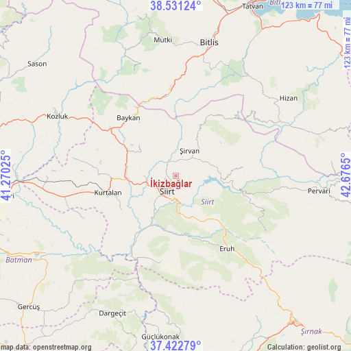
İkizbağlar GPS coordinates[2]
37° 58' 44.796" North, 41° 58' 24.132" East
| Map corner | latitude | longitude |
|---|---|---|
| Upper-left | 38.53124°, | 41.27025° |
| Center: | 37.97911°, | 41.97337° |
| Lower-right: | 37.42279°, | 42.6765° |
| Map W x H: | 123.2×123.2 km | = 76.6×76.6mi |
| max Lat: | 42.02683° ⇑62% North |
| İkizbağlar: | 37.97911° |
| min Lat: | ⇓38% South 35.9025° |
| min Long | İkizbağlar | max Long |
| 25.90902° | 41.97337° | 44.60099° |
| W 90.2%⇐ | ⇒9.8% E |
Elevation
Elevation of İkizbağlar is 1079 m = 3540 ft, and this is 361.6 m = 1186 ft above average elevation for this country.
| Max E: |
2682 m = 8799 ft | 26.6% |
| İkizbağlar | 1079 m 3540 ft | |
| Avg. | 717.4 m = 2354 ft | |
Min E: |
0 m = 0 ft | 73.4% |
See also: Turkey elevation on elevation.city.
Geographical zone
İkizbağlar is located in North temperate zone (between Tropic of Cancer and the Arctic Circle). Distance of this Northern Tropic circle is 1617 km =1004.8 mi to South.| Distance of | km | miles | from İkizbağlar |
|---|---|---|---|
| North Pole | 5784.2 | 3594.1 | to North |
| Arctic Circle | 3178.3 | 1974.9 | to North |
| Tropic Cancer | 1617 | 1004.8 | to South |
| Equator | 4222.9 | 2624 | to South |


Nearby cities:
15 places around İkizbağlar: (largest is in red/bold)
• Aktaş
14.9 km =9.3 mi,  259°
259°
• Bağlıca
23 km =14.3 mi,  238°
238°
• Civankan
11.9 km =7.4 mi,  224°
224°
• Dilektepe
16.7 km =10.4 mi,  309°
309°
• Doluharman
5.1 km =3.2 mi,  278°
278°
• Durankaya
18.2 km =11.3 mi,  87°
87°
• Ekmekçiler
17.1 km =10.6 mi,  127°
127°
• Kurtalan
26 km =16.2 mi, 256°
• Meydandere
12.3 km =7.6 mi,  118°
118°
• Palamutlu
22.1 km =13.7 mi,  114°
114°
• Siirt
6.2 km =3.9 mi,  206°
206°
• Taşlı
14.2 km =8.8 mi, 86°
• Tillo
4.8 km =3 mi, 134°
• Özpınar
23.9 km =14.9 mi,  83°
83°
• Şirvan
10.3 km =6.4 mi,  26°
26°
Sources, notices
• [Note1] Compared only with cities in Turkey existing in our database
• [Src1] Map data: © OpenStreetMap contributors (CC-BY-SA)
• [Src2] Other city data from geonames.org with taken over terms of usage.
• [Src3] Geographical zone / Annual Mean Temperature by Robert A. Rohde @ Wikipedia
