Karakurt geodata
Karakurt (Kars) is a seat of a third-order administrative division; located in Turkey in Europe/Istanbul (GMT+3) time zone. In our database, there are 1323 cities with bigger population. Compared to other cities in Turkey, 71.8% of cities are located further ↓South; 94.8% of cities are located further ←West and 90.3% of cities have lower elevation than Karakurt. Note1


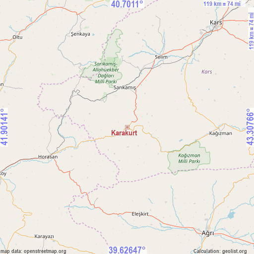
Karakurt GPS coordinates[2]
40° 9' 57.276" North, 42° 36' 16.308" East
| Map corner | latitude | longitude |
|---|---|---|
| Upper-left | 40.7011°, | 41.90141° |
| Center: | 40.16591°, | 42.60453° |
| Lower-right: | 39.62647°, | 43.30766° |
| Map W x H: | 119.5×119.5 km | = 74.3×74.3mi |
| max Lat: | 42.02683° ⇑28.2% North |
| Karakurt: | 40.16591° |
| min Lat: | ⇓71.8% South 35.9025° |
| min Long | Karakurt | max Long |
| 25.90902° | 42.60453° | 44.60099° |
| W 94.8%⇐ | ⇒5.2% E |
Elevation
Elevation of Karakurt is 1485 m = 4872 ft, and this is 767.6 m = 2518 ft above average elevation for this country.
| Max E: |
2682 m = 8799 ft | 9.7% |
| Karakurt | 1485 m 4872 ft | |
| Avg. | 717.4 m = 2354 ft | |
Min E: |
0 m = 0 ft | 90.3% |
See also: Turkey elevation on elevation.city.
Geographical zone
Karakurt is located in North temperate zone (between Tropic of Cancer and the Arctic Circle). Distance of this Northern Tropic circle is 1860.1 km =1155.8 mi to South.| Distance of | km | miles | from Karakurt |
|---|---|---|---|
| North Pole | 5541 | 3443 | to North |
| Arctic Circle | 2935.1 | 1823.8 | to North |
| Tropic Cancer | 1860.1 | 1155.8 | to South |
| Equator | 4466 | 2775 | to South |


Nearby cities:
15 places around Karakurt: (largest is in red/bold)
• Akşar
58 km =36 mi,  337°
337°
• Aras
32.2 km =20 mi,  232°
232°
• Cumaçay
56.8 km =35.3 mi,  119°
119°
• Eleşkirt
41.4 km =25.7 mi,  171°
171°
• Gaziler
35.8 km =22.2 mi,  322°
322°
• Horasan
40.1 km =24.9 mi,  249°
249°
• Karaurgan
29.3 km =18.2 mi,  286°
286°
• Kağızman
45 km =28 mi,  91°
91°
• Kötek
34.3 km =21.3 mi,  80°
80°
• Kışlaköy
52.4 km =32.6 mi, 289°
• Sarıkamış
18 km =11.2 mi,  355°
355°
• Selim
35.8 km =22.2 mi,  24°
24°
• Tahir
37.6 km =23.4 mi,  203°
203°
• Çiftlik
31.4 km =19.5 mi, 250°
• Şenkaya
48.8 km =30.3 mi,  332°
332°
Sources, notices
• [Note1] Compared only with cities in Turkey existing in our database
• [Src1] Map data: © OpenStreetMap contributors (CC-BY-SA)
• [Src2] Other city data from geonames.org with taken over terms of usage.
• [Src3] Geographical zone / Annual Mean Temperature by Robert A. Rohde @ Wikipedia
