Sarıkamış geodata
Sarıkamış (Kars) is a seat of a second-order administrative division; located in Turkey in Europe/Istanbul (GMT+3) time zone. With population of 23,665 people, there are 301 cities with bigger population in this country. Compared to other cities in Turkey, 74.8% of cities are located further ↓South; 94.7% of cities are located further ←West and 99.5% of cities have lower elevation than Sarıkamış. Note1


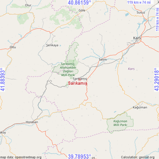
Sarıkamış GPS coordinates[2]
40° 19' 39.684" North, 42° 35' 13.38" East
| Map corner | latitude | longitude |
|---|---|---|
| Upper-left | 40.86159°, | 41.88393° |
| Center: | 40.32769°, | 42.58705° |
| Lower-right: | 39.78953°, | 43.29018° |
| Map W x H: | 119.2×119.2 km | = 74.1×74.1mi |
| max Lat: | 42.02683° ⇑25.2% North |
| Sarıkamış: | 40.32769° |
| min Lat: | ⇓74.8% South 35.9025° |
| min Long | Sarıkamış | max Long |
| 25.90902° | 42.58705° | 44.60099° |
| W 94.7%⇐ | ⇒5.3% E |
Elevation
Elevation of Sarıkamış is 2087 m = 6847 ft, and this is 1369.6 m = 4493 ft above average elevation for this country.
| Max E: |
2682 m = 8799 ft | 0.5% |
| Sarıkamış | 2087 m 6847 ft | |
| Avg. | 717.4 m = 2354 ft | |
Min E: |
0 m = 0 ft | 99.5% |
See also: Turkey elevation on elevation.city.
Geographical zone
Sarıkamış is located in North temperate zone (between Tropic of Cancer and the Arctic Circle). Distance of this Northern Tropic circle is 1878.1 km =1167 mi to South.| Distance of | km | miles | from Sarıkamış |
|---|---|---|---|
| North Pole | 5523 | 3431.8 | to North |
| Arctic Circle | 2917.2 | 1812.7 | to North |
| Tropic Cancer | 1878.1 | 1167 | to South |
| Equator | 4484 | 2786.2 | to South |


Nearby cities:
15 places around Sarıkamış: (largest is in red/bold)
• Akşar
41.2 km =25.6 mi,  329°
329°
• Aras
44.7 km =27.8 mi,  212°
212°
• Gaziler
22.8 km =14.2 mi,  297°
297°
• Göle
51.1 km =31.8 mi,  1°
1°
• Horasan
48.2 km =30 mi,  228°
228°
• Karakurt
18 km =11.2 mi,  175°
175°
• Karaurgan
28.4 km =17.6 mi,  249°
249°
• Kars
51.8 km =32.2 mi,  54°
54°
• Kağızman
50.2 km =31.2 mi,  112°
112°
• Kömürlü
51.9 km =32.2 mi, 330°
• Kötek
37.3 km =23.2 mi, 109°
• Kışlaköy
47.9 km =29.8 mi,  269°
269°
• Selim
22 km =13.7 mi, 48°
• Çiftlik
39.9 km =24.8 mi,  224°
224°
• Şenkaya
32.8 km =20.4 mi,  320°
320°
Sources, notices
• [Note1] Compared only with cities in Turkey existing in our database
• [Src1] Map data: © OpenStreetMap contributors (CC-BY-SA)
• [Src2] Other city data from geonames.org with taken over terms of usage.
• [Src3] Geographical zone / Annual Mean Temperature by Robert A. Rohde @ Wikipedia
