Kâhta geodata
Kâhta (Adıyaman) is a seat of a second-order administrative division; located in Turkey in Europe/Istanbul (GMT+3) time zone. With population of 73,105 people, there are 126 cities with bigger population in this country. Compared to other cities in Turkey, 68.8% of cities are located further ↑North; 64.9% of cities are located further ←West and 51.2% of cities have lower elevation than Kâhta. Note1


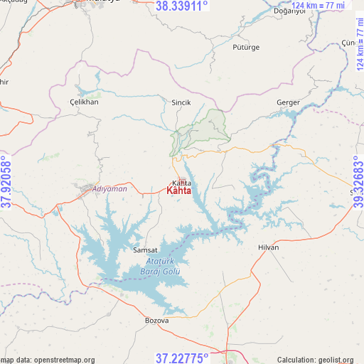
Kâhta GPS coordinates[2]
37° 47' 7.872" North, 38° 37' 25.32" East
| Map corner | latitude | longitude |
|---|---|---|
| Upper-left | 38.33911°, | 37.92058° |
| Center: | 37.78552°, | 38.6237° |
| Lower-right: | 37.22775°, | 39.32683° |
| Map W x H: | 123.6×123.6 km | = 76.8×76.8mi |
| max Lat: | 42.02683° ⇑68.8% North |
| Kâhta: | 37.78552° |
| min Lat: | ⇓31.2% South 35.9025° |
| min Long | Kâhta | max Long |
| 25.90902° | 38.6237° | 44.60099° |
| W 64.9%⇐ | ⇒35.1% E |
Elevation
Elevation of Kâhta is 722 m = 2369 ft, and this is 4.6 m = 15 ft above average elevation for this country.
| Max E: |
2682 m = 8799 ft | 48.8% |
| Kâhta | 722 m 2369 ft | |
| Avg. | 717.4 m = 2354 ft | |
Min E: |
0 m = 0 ft | 51.2% |
See also: Kâhta elevation on elevation.city.
Geographical zone
Kâhta is located in North temperate zone (between Tropic of Cancer and the Arctic Circle). Distance of this Northern Tropic circle is 1595.4 km =991.3 mi to South.| Distance of | km | miles | from Kâhta |
|---|---|---|---|
| North Pole | 5805.7 | 3607.5 | to North |
| Arctic Circle | 3199.8 | 1988.3 | to North |
| Tropic Cancer | 1595.4 | 991.3 | to South |
| Equator | 4201.4 | 2610.6 | to South |


Nearby cities:
15 places around Kâhta: (largest is in red/bold)
• Adıyaman
30.6 km =19 mi,  265°
265°
• Akıncılar
17.7 km =11 mi,  97°
97°
• Bağpınar
34.4 km =21.4 mi,  231°
231°
• Damlacık
14.6 km =9.1 mi,  10°
10°
• Gerger
39 km =24.2 mi,  62°
62°
• Hilvan
36.6 km =22.7 mi,  127°
127°
• Koçali
35.6 km =22.1 mi,  295°
295°
• Kuyucak
26.1 km =16.2 mi,  289°
289°
• Narince
16.1 km =10 mi,  47°
47°
• Ovacık
33.2 km =20.6 mi,  155°
155°
• Samsat
26.2 km =16.3 mi,  210°
210°
• Sincik
27.9 km =17.3 mi,  357°
357°
• Tepehan
38 km =23.6 mi, 13°
• Yarpuzlu
31.2 km =19.4 mi,  343°
343°
• Çaylarbaşı
35.2 km =21.9 mi,  105°
105°
Sources, notices
• [Note1] Compared only with cities in Turkey existing in our database
• [Src1] Map data: © OpenStreetMap contributors (CC-BY-SA)
• [Src2] Other city data from geonames.org with taken over terms of usage.
• [Src3] Geographical zone / Annual Mean Temperature by Robert A. Rohde @ Wikipedia
