Damlacık geodata
Damlacık (Adıyaman) is a seat of a third-order administrative division; located in Turkey in Europe/Istanbul (GMT+3) time zone. In our database, there are 1323 cities with bigger population. Compared to other cities in Turkey, 64.4% of cities are located further ↑North; 64.9% of cities are located further ←West and 54.3% of cities have lower elevation than Damlacık. Note1


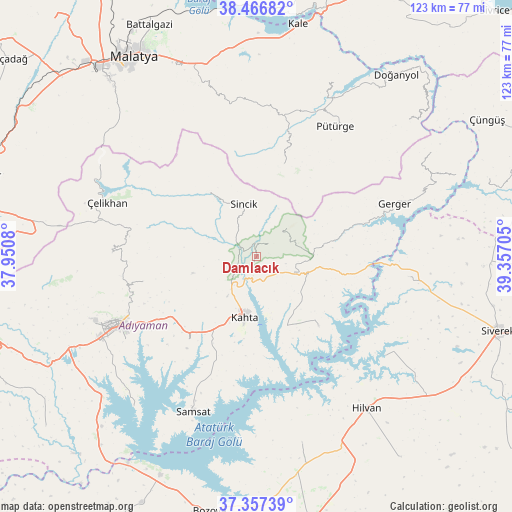
Damlacık GPS coordinates[2]
37° 54' 51.12" North, 38° 39' 14.112" East
| Map corner | latitude | longitude |
|---|---|---|
| Upper-left | 38.46682°, | 37.9508° |
| Center: | 37.9142°, | 38.65392° |
| Lower-right: | 37.35739°, | 39.35705° |
| Map W x H: | 123.4×123.4 km | = 76.7×76.7mi |
| max Lat: | 42.02683° ⇑64.4% North |
| Damlacık: | 37.9142° |
| min Lat: | ⇓35.6% South 35.9025° |
| min Long | Damlacık | max Long |
| 25.90902° | 38.65392° | 44.60099° |
| W 64.9%⇐ | ⇒35.1% E |
Elevation
Elevation of Damlacık is 782 m = 2566 ft, and this is 64.6 m = 212 ft above average elevation for this country.
| Max E: |
2682 m = 8799 ft | 45.7% |
| Damlacık | 782 m 2566 ft | |
| Avg. | 717.4 m = 2354 ft | |
Min E: |
0 m = 0 ft | 54.3% |
See also: Turkey elevation on elevation.city.
Geographical zone
Damlacık is located in North temperate zone (between Tropic of Cancer and the Arctic Circle). Distance of this Northern Tropic circle is 1609.7 km =1000.2 mi to South.| Distance of | km | miles | from Damlacık |
|---|---|---|---|
| North Pole | 5791.4 | 3598.6 | to North |
| Arctic Circle | 3185.5 | 1979.4 | to North |
| Tropic Cancer | 1609.7 | 1000.2 | to South |
| Equator | 4215.7 | 2619.5 | to South |


Nearby cities:
15 places around Damlacık: (largest is in red/bold)
• Adıyaman
37.1 km =23.1 mi,  243°
243°
• Akıncılar
22.3 km =13.9 mi,  138°
138°
• Bucak
36.2 km =22.5 mi,  97°
97°
• Gerger
32.1 km =19.9 mi,  82°
82°
• Gerger
35.7 km =22.2 mi,  69°
69°
• Koçali
34.8 km =21.6 mi,  271°
271°
• Kuyucak
27.8 km =17.3 mi,  258°
258°
• Kâhta
14.6 km =9.1 mi,  190°
190°
• Narince
9.9 km =6.2 mi,  110°
110°
• Pütürge
36.6 km =22.7 mi,  30°
30°
• Sincik
14.1 km =8.8 mi,  345°
345°
• Taraksu
39.3 km =24.4 mi, 73°
• Tepehan
23.5 km =14.6 mi,  15°
15°
• Yarpuzlu
19.4 km =12.1 mi,  323°
323°
• Çelikhan
38.6 km =24 mi,  288°
288°
Sources, notices
• [Note1] Compared only with cities in Turkey existing in our database
• [Src1] Map data: © OpenStreetMap contributors (CC-BY-SA)
• [Src2] Other city data from geonames.org with taken over terms of usage.
• [Src3] Geographical zone / Annual Mean Temperature by Robert A. Rohde @ Wikipedia
