Kaynar geodata
Kaynar (Kayseri) is a seat of a third-order administrative division; located in Turkey in Europe/Istanbul (GMT+3) time zone. In our database, there are 1323 cities with bigger population. Compared to other cities in Turkey, 53.2% of cities are located further ↓South; 54.4% of cities are located further ←West and 92.8% of cities have lower elevation than Kaynar. Note1


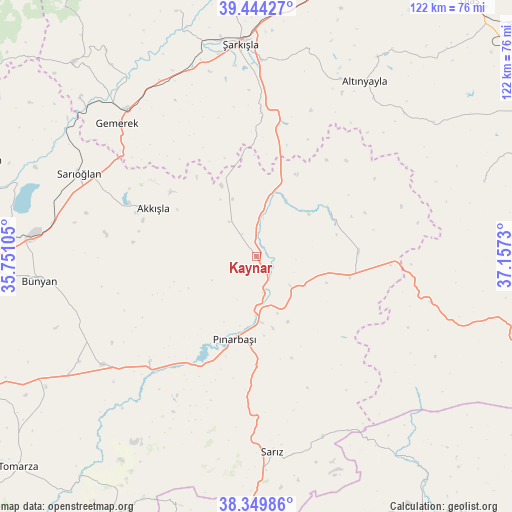
Kaynar GPS coordinates[2]
38° 53' 57.012" North, 36° 27' 15.012" East
| Map corner | latitude | longitude |
|---|---|---|
| Upper-left | 39.44427°, | 35.75105° |
| Center: | 38.89917°, | 36.45417° |
| Lower-right: | 38.34986°, | 37.1573° |
| Map W x H: | 121.7×121.7 km | = 75.6×75.6mi |
| max Lat: | 42.02683° ⇑46.8% North |
| Kaynar: | 38.89917° |
| min Lat: | ⇓53.2% South 35.9025° |
| min Long | Kaynar | max Long |
| 25.90902° | 36.45417° | 44.60099° |
| W 54.4%⇐ | ⇒45.6% E |
Elevation
Elevation of Kaynar is 1565 m = 5135 ft, and this is 847.6 m = 2781 ft above average elevation for this country.
| Max E: |
2682 m = 8799 ft | 7.2% |
| Kaynar | 1565 m 5135 ft | |
| Avg. | 717.4 m = 2354 ft | |
Min E: |
0 m = 0 ft | 92.8% |
See also: Turkey elevation on elevation.city.
Geographical zone
Kaynar is located in North temperate zone (between Tropic of Cancer and the Arctic Circle). Distance of this Northern Tropic circle is 1719.3 km =1068.3 mi to South.| Distance of | km | miles | from Kaynar |
|---|---|---|---|
| North Pole | 5681.9 | 3530.6 | to North |
| Arctic Circle | 3076 | 1911.3 | to North |
| Tropic Cancer | 1719.3 | 1068.3 | to South |
| Equator | 4325.2 | 2687.6 | to South |


Nearby cities:
15 places around Kaynar: (largest is in red/bold)
• Akkışla
26.8 km =16.7 mi,  295°
295°
• Altınyayla
48.8 km =30.3 mi,  31°
31°
• Bünyan
51.7 km =32.1 mi,  263°
263°
• Elbaşı
49.1 km =30.5 mi,  239°
239°
• Gemerek
45.7 km =28.4 mi,  313°
313°
• Kuşkayası
56.9 km =35.4 mi,  71°
71°
• Ortaköy
61.1 km =38 mi,  341°
341°
• Pazarören
35.8 km =22.2 mi,  225°
225°
• Pınarbaşı
20.3 km =12.6 mi,  195°
195°
• Sarıoğlan
46.5 km =28.9 mi, 295°
• Sarız
46.9 km =29.1 mi,  175°
175°
• Toklar
65.7 km =40.8 mi,  215°
215°
• Yazyurdu
42.8 km =26.6 mi,  105°
105°
• Örenşehir
20.2 km =12.6 mi,  56°
56°
• Şarkışla
50.5 km =31.4 mi,  355°
355°
Sources, notices
• [Note1] Compared only with cities in Turkey existing in our database
• [Src1] Map data: © OpenStreetMap contributors (CC-BY-SA)
• [Src2] Other city data from geonames.org with taken over terms of usage.
• [Src3] Geographical zone / Annual Mean Temperature by Robert A. Rohde @ Wikipedia
