Sarayönü geodata
Sarayönü (Konya) is a seat of a second-order administrative division; located in Turkey in Europe/Istanbul (GMT+3) time zone. With population of 10,198 people, there are 503 cities with bigger population in this country. Compared to other cities in Turkey, 56.9% of cities are located further ↑North; 64.9% of cities are located further →East and 72.3% of cities have lower elevation than Sarayönü. Note1


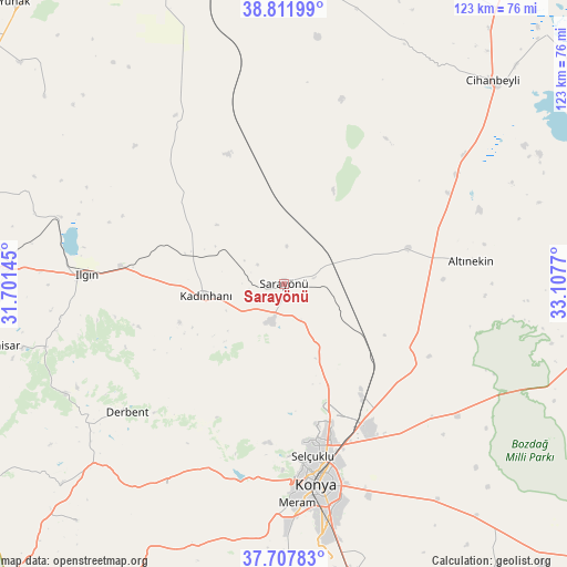
Sarayönü GPS coordinates[2]
38° 15' 43.236" North, 32° 24' 16.452" East
| Map corner | latitude | longitude |
|---|---|---|
| Upper-left | 38.81199°, | 31.70145° |
| Center: | 38.26201°, | 32.40457° |
| Lower-right: | 37.70783°, | 33.1077° |
| Map W x H: | 122.8×122.8 km | = 76.3×76.3mi |
| max Lat: | 42.02683° ⇑56.9% North |
| Sarayönü: | 38.26201° |
| min Lat: | ⇓43.1% South 35.9025° |
| min Long | Sarayönü | max Long |
| 25.90902° | 32.40457° | 44.60099° |
| W 35.1%⇐ | ⇒64.9% E |
Elevation
Elevation of Sarayönü is 1062 m = 3484 ft, and this is 344.6 m = 1131 ft above average elevation for this country.
| Max E: |
2682 m = 8799 ft | 27.7% |
| Sarayönü | 1062 m 3484 ft | |
| Avg. | 717.4 m = 2354 ft | |
Min E: |
0 m = 0 ft | 72.3% |
See also: Turkey elevation on elevation.city.
Geographical zone
Sarayönü is located in North temperate zone (between Tropic of Cancer and the Arctic Circle). Distance of this Northern Tropic circle is 1648.4 km =1024.3 mi to South.| Distance of | km | miles | from Sarayönü |
|---|---|---|---|
| North Pole | 5752.7 | 3574.6 | to North |
| Arctic Circle | 3146.8 | 1955.3 | to North |
| Tropic Cancer | 1648.4 | 1024.3 | to South |
| Equator | 4254.3 | 2643.5 | to South |


Nearby cities:
15 places around Sarayönü: (largest is in red/bold)
• Altınekin
40.8 km =25.4 mi,  82°
82°
• Aşağıpınarbaşı
30.2 km =18.8 mi,  145°
145°
• Aşağıçiğil
52.8 km =32.8 mi,  243°
243°
• Derbent
43.7 km =27.2 mi,  230°
230°
• Hatip
56.5 km =35.1 mi,  178°
178°
• Ilgın
42.9 km =26.7 mi,  272°
272°
• Kadınhanı
17 km =10.6 mi,  261°
261°
• Karatay
45.2 km =28.1 mi,  166°
166°
• Konya
44 km =27.3 mi, 170°
• Kurthasanlı
21.2 km =13.2 mi,  289°
289°
• Kuyulusebil
44.9 km =27.9 mi,  14°
14°
• Kızılören
50.5 km =31.4 mi,  209°
209°
• Meram
48.4 km =30.1 mi, 173°
• Selçuklu
42.7 km =26.5 mi, 169°
• Sille
37.2 km =23.1 mi, 177°
Sources, notices
• [Note1] Compared only with cities in Turkey existing in our database
• [Src1] Map data: © OpenStreetMap contributors (CC-BY-SA)
• [Src2] Other city data from geonames.org with taken over terms of usage.
• [Src3] Geographical zone / Annual Mean Temperature by Robert A. Rohde @ Wikipedia
