Bayburt geodata
Bayburt is a seat of a first-order administrative division; located in Turkey in Europe/Istanbul (GMT+3) time zone. With population of 31,258 people, there are 243 cities with bigger population in this country. Compared to other cities in Turkey, 73.7% of cities are located further ↓South; 75.1% of cities are located further ←West and 92.7% of cities have lower elevation than Bayburt. Note1


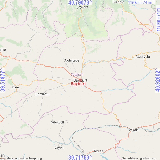
Bayburt GPS coordinates[2]
40° 15' 22.716" North, 40° 13' 22.404" East
| Map corner | latitude | longitude |
|---|---|---|
| Upper-left | 40.79078°, | 39.51977° |
| Center: | 40.25631°, | 40.22289° |
| Lower-right: | 39.71759°, | 40.92602° |
| Map W x H: | 119.3×119.3 km | = 74.1×74.1mi |
| max Lat: | 42.02683° ⇑26.3% North |
| Bayburt: | 40.25631° |
| min Lat: | ⇓73.7% South 35.9025° |
| min Long | Bayburt | max Long |
| 25.90902° | 40.22289° | 44.60099° |
| W 75.1%⇐ | ⇒24.9% E |
Elevation
Elevation of Bayburt is 1564 m = 5131 ft, and this is 846.6 m = 2778 ft above average elevation for this country.
| Max E: |
2682 m = 8799 ft | 7.3% |
| Bayburt | 1564 m 5131 ft | |
| Avg. | 717.4 m = 2354 ft | |
Min E: |
0 m = 0 ft | 92.7% |
See also: Turkey elevation on elevation.city.
Geographical zone
Bayburt is located in North temperate zone (between Tropic of Cancer and the Arctic Circle). Distance of this Northern Tropic circle is 1870.2 km =1162.1 mi to South.| Distance of | km | miles | from Bayburt |
|---|---|---|---|
| North Pole | 5531 | 3436.8 | to North |
| Arctic Circle | 2925.1 | 1817.6 | to North |
| Tropic Cancer | 1870.2 | 1162.1 | to South |
| Equator | 4476.1 | 2781.3 | to South |


Nearby cities:
15 places around Bayburt: (largest is in red/bold)
• Aydıntepe
15.7 km =9.8 mi,  334°
334°
• Aşkale
54.8 km =34.1 mi,  132°
132°
• Başköy
53.6 km =33.3 mi,  217°
217°
• Dağbaşı
58.6 km =36.4 mi, 333°
• Kale
48 km =29.8 mi,  287°
287°
• Köse
49.3 km =30.6 mi,  263°
263°
• Maden
17.5 km =10.9 mi,  118°
118°
• Otlukbeli
36.3 km =22.6 mi,  208°
208°
• Pazaryolu
49.3 km =30.6 mi,  69°
69°
• Pulur
30 km =18.6 mi,  249°
249°
• Tercan
54.9 km =34.1 mi,  166°
166°
• Uzungöl
40.4 km =25.1 mi,  7°
7°
• Yağmurdere
46.8 km =29.1 mi,  319°
319°
• Çaykara
54.1 km =33.6 mi,  0°
0°
• Çayırlı
52.6 km =32.7 mi,  198°
198°
Sources, notices
• [Note1] Compared only with cities in Turkey existing in our database
• [Src1] Map data: © OpenStreetMap contributors (CC-BY-SA)
• [Src2] Other city data from geonames.org with taken over terms of usage.
• [Src3] Geographical zone / Annual Mean Temperature by Robert A. Rohde @ Wikipedia
