Ortaköy geodata
Ortaköy (Aksaray) is a seat of a second-order administrative division; located in Turkey in Europe/Istanbul (GMT+3) time zone. With population of 31,144 people, there are 244 cities with bigger population in this country. Compared to other cities in Turkey, 50.8% of cities are located further ↓South; 58.2% of cities are located further →East and 81.6% of cities have lower elevation than Ortaköy. Note1


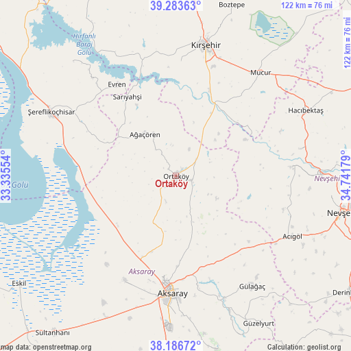
Ortaköy GPS coordinates[2]
38° 44' 14.208" North, 34° 2' 19.176" East
| Map corner | latitude | longitude |
|---|---|---|
| Upper-left | 39.28363°, | 33.33554° |
| Center: | 38.73728°, | 34.03866° |
| Lower-right: | 38.18672°, | 34.74179° |
| Map W x H: | 122×122 km | = 75.8×75.8mi |
| max Lat: | 42.02683° ⇑49.2% North |
| Ortaköy: | 38.73728° |
| min Lat: | ⇓50.8% South 35.9025° |
| min Long | Ortaköy | max Long |
| 25.90902° | 34.03866° | 44.60099° |
| W 41.8%⇐ | ⇒58.2% E |
Elevation
Elevation of Ortaköy is 1226 m = 4022 ft, and this is 508.6 m = 1669 ft above average elevation for this country.
| Max E: |
2682 m = 8799 ft | 18.4% |
| Ortaköy | 1226 m 4022 ft | |
| Avg. | 717.4 m = 2354 ft | |
Min E: |
0 m = 0 ft | 81.6% |
See also: Turkey elevation on elevation.city.
Geographical zone
Ortaköy is located in North temperate zone (between Tropic of Cancer and the Arctic Circle). Distance of this Northern Tropic circle is 1701.3 km =1057.1 mi to South.| Distance of | km | miles | from Ortaköy |
|---|---|---|---|
| North Pole | 5699.9 | 3541.8 | to North |
| Arctic Circle | 3094 | 1922.5 | to North |
| Tropic Cancer | 1701.3 | 1057.1 | to South |
| Equator | 4307.2 | 2676.4 | to South |


Nearby cities:
15 places around Ortaköy: (largest is in red/bold)
• Acıgöl
45.8 km =28.5 mi,  116°
116°
• Acıpınar
28.5 km =17.7 mi,  214°
214°
• Aksaray
40.6 km =25.2 mi,  181°
181°
• Ağaçören
18.6 km =11.6 mi,  325°
325°
• Balcı
5.6 km =3.5 mi,  103°
103°
• Evren
37.7 km =23.4 mi, 327°
• Gülağaç
46.4 km =28.8 mi,  144°
144°
• Gülşehir
50.9 km =31.6 mi,  88°
88°
• Hacıbektaş
50.3 km =31.3 mi,  63°
63°
• Kırşehir
46.7 km =29 mi,  13°
13°
• Mucur
46.8 km =29.1 mi,  39°
39°
• Salanda
43.9 km =27.3 mi,  77°
77°
• Sarıyahşi
32.3 km =20.1 mi, 328°
• Yeşilova
40.4 km =25.1 mi, 205°
• Şereflikoçhisar
48.8 km =30.3 mi,  297°
297°
Sources, notices
• [Note1] Compared only with cities in Turkey existing in our database
• [Src1] Map data: © OpenStreetMap contributors (CC-BY-SA)
• [Src2] Other city data from geonames.org with taken over terms of usage.
• [Src3] Geographical zone / Annual Mean Temperature by Robert A. Rohde @ Wikipedia
