Balcı geodata
Balcı (Aksaray) is a seat of a third-order administrative division; located in Turkey in Europe/Istanbul (GMT+3) time zone. In our database, there are 1323 cities with bigger population. Compared to other cities in Turkey, 50.4% of cities are located further ↓South; 58% of cities are located further →East and 78.3% of cities have lower elevation than Balcı. Note1


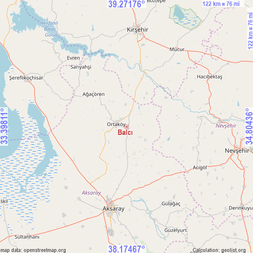
Balcı GPS coordinates[2]
38° 43' 31.152" North, 34° 6' 4.428" East
| Map corner | latitude | longitude |
|---|---|---|
| Upper-left | 39.27176°, | 33.39811° |
| Center: | 38.72532°, | 34.10123° |
| Lower-right: | 38.17467°, | 34.80436° |
| Map W x H: | 122×122 km | = 75.8×75.8mi |
| max Lat: | 42.02683° ⇑49.6% North |
| Balcı: | 38.72532° |
| min Lat: | ⇓50.4% South 35.9025° |
| min Long | Balcı | max Long |
| 25.90902° | 34.10123° | 44.60099° |
| W 42%⇐ | ⇒58% E |
Elevation
Elevation of Balcı is 1160 m = 3806 ft, and this is 442.6 m = 1452 ft above average elevation for this country.
| Max E: |
2682 m = 8799 ft | 21.7% |
| Balcı | 1160 m 3806 ft | |
| Avg. | 717.4 m = 2354 ft | |
Min E: |
0 m = 0 ft | 78.3% |
See also: Turkey elevation on elevation.city.
Geographical zone
Balcı is located in North temperate zone (between Tropic of Cancer and the Arctic Circle). Distance of this Northern Tropic circle is 1699.9 km =1056.3 mi to South.| Distance of | km | miles | from Balcı |
|---|---|---|---|
| North Pole | 5701.2 | 3542.6 | to North |
| Arctic Circle | 3095.3 | 1923.3 | to North |
| Tropic Cancer | 1699.9 | 1056.3 | to South |
| Equator | 4305.9 | 2675.6 | to South |


Nearby cities:
15 places around Balcı: (largest is in red/bold)
• Acıgöl
40.4 km =25.1 mi,  118°
118°
• Acıpınar
30.9 km =19.2 mi,  224°
224°
• Aksaray
39.8 km =24.7 mi,  189°
189°
• Ağaçören
23.1 km =14.4 mi,  316°
316°
• Evren
41.9 km =26 mi, 322°
• Gülağaç
42.4 km =26.3 mi,  149°
149°
• Gülşehir
45.5 km =28.3 mi,  87°
87°
• Hacıbektaş
46.2 km =28.7 mi,  58°
58°
• Kırşehir
47.1 km =29.3 mi,  6°
6°
• Mucur
44.6 km =27.7 mi,  33°
33°
• Nevşehir
54.2 km =33.7 mi,  101°
101°
• Ortaköy
5.6 km =3.5 mi,  283°
283°
• Salanda
39 km =24.2 mi,  73°
73°
• Sarıyahşi
36.5 km =22.7 mi, 321°
• Yeşilova
41.9 km =26 mi,  213°
213°
Sources, notices
• [Note1] Compared only with cities in Turkey existing in our database
• [Src1] Map data: © OpenStreetMap contributors (CC-BY-SA)
• [Src2] Other city data from geonames.org with taken over terms of usage.
• [Src3] Geographical zone / Annual Mean Temperature by Robert A. Rohde @ Wikipedia
