Ağaçören geodata
Ağaçören (Aksaray) is a seat of a second-order administrative division; located in Turkey in Europe/Istanbul (GMT+3) time zone. With population of 5,822 people, there are 664 cities with bigger population in this country. Compared to other cities in Turkey, 52.9% of cities are located further ↓South; 58.6% of cities are located further →East and 81.9% of cities have lower elevation than Ağaçören. Note1


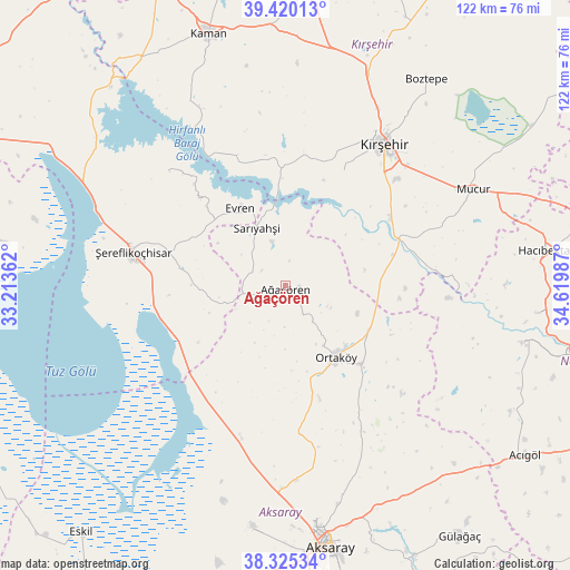
Ağaçören GPS coordinates[2]
38° 52' 29.424" North, 33° 55' 0.264" East
| Map corner | latitude | longitude |
|---|---|---|
| Upper-left | 39.42013°, | 33.21362° |
| Center: | 38.87484°, | 33.91674° |
| Lower-right: | 38.32534°, | 34.61987° |
| Map W x H: | 121.7×121.7 km | = 75.6×75.6mi |
| max Lat: | 42.02683° ⇑47.1% North |
| Ağaçören: | 38.87484° |
| min Lat: | ⇓52.9% South 35.9025° |
| min Long | Ağaçören | max Long |
| 25.90902° | 33.91674° | 44.60099° |
| W 41.4%⇐ | ⇒58.6% E |
Elevation
Elevation of Ağaçören is 1232 m = 4042 ft, and this is 514.6 m = 1688 ft above average elevation for this country.
| Max E: |
2682 m = 8799 ft | 18.1% |
| Ağaçören | 1232 m 4042 ft | |
| Avg. | 717.4 m = 2354 ft | |
Min E: |
0 m = 0 ft | 81.9% |
See also: Turkey elevation on elevation.city.
Geographical zone
Ağaçören is located in North temperate zone (between Tropic of Cancer and the Arctic Circle). Distance of this Northern Tropic circle is 1716.6 km =1066.6 mi to South.| Distance of | km | miles | from Ağaçören |
|---|---|---|---|
| North Pole | 5684.6 | 3532.2 | to North |
| Arctic Circle | 3078.7 | 1913 | to North |
| Tropic Cancer | 1716.6 | 1066.6 | to South |
| Equator | 4322.5 | 2685.9 | to South |


Nearby cities:
15 places around Ağaçören: (largest is in red/bold)
• Acıpınar
39.1 km =24.3 mi,  188°
188°
• Aksaray
56.6 km =35.2 mi,  170°
170°
• Balcı
23.1 km =14.4 mi,  136°
136°
• Boztepe
53 km =32.9 mi,  34°
34°
• Evren
19.1 km =11.9 mi,  330°
330°
• Hacıbektaş
55.9 km =34.7 mi,  82°
82°
• Kaman
56.2 km =34.9 mi,  342°
342°
• Kırşehir
36.9 km =22.9 mi,  35°
35°
• Mucur
45.3 km =28.1 mi,  62°
62°
• Ortaköy
18.6 km =11.6 mi,  145°
145°
• Salanda
53.6 km =33.3 mi,  95°
95°
• Sarıyahşi
13.7 km =8.5 mi, 331°
• Savcılı
44.3 km =27.5 mi, 332°
• Yeşilova
52.2 km =32.4 mi, 187°
• Şereflikoçhisar
33.5 km =20.8 mi,  282°
282°
Sources, notices
• [Note1] Compared only with cities in Turkey existing in our database
• [Src1] Map data: © OpenStreetMap contributors (CC-BY-SA)
• [Src2] Other city data from geonames.org with taken over terms of usage.
• [Src3] Geographical zone / Annual Mean Temperature by Robert A. Rohde @ Wikipedia
