Keban geodata
Keban (Elazığ) is a seat of a second-order administrative division; located in Turkey in Europe/Istanbul (GMT+3) time zone. With population of 5,837 people, there are 663 cities with bigger population in this country. Compared to other cities in Turkey, 51.7% of cities are located further ↓South; 65.4% of cities are located further ←West and 52.3% of cities have lower elevation than Keban. Note1


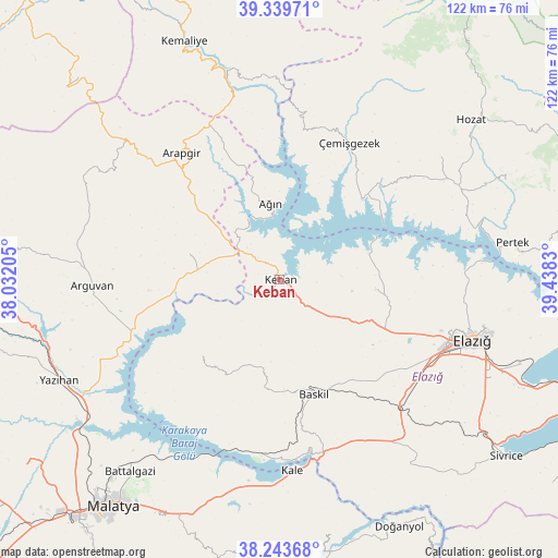
Keban GPS coordinates[2]
38° 47' 37.68" North, 38° 44' 6.612" East
| Map corner | latitude | longitude |
|---|---|---|
| Upper-left | 39.33971°, | 38.03205° |
| Center: | 38.7938°, | 38.73517° |
| Lower-right: | 38.24368°, | 39.4383° |
| Map W x H: | 121.9×121.9 km | = 75.7×75.7mi |
| max Lat: | 42.02683° ⇑48.3% North |
| Keban: | 38.7938° |
| min Lat: | ⇓51.7% South 35.9025° |
| min Long | Keban | max Long |
| 25.90902° | 38.73517° | 44.60099° |
| W 65.4%⇐ | ⇒34.6% E |
Elevation
Elevation of Keban is 746 m = 2448 ft, and this is 28.6 m = 94 ft above average elevation for this country.
| Max E: |
2682 m = 8799 ft | 47.7% |
| Keban | 746 m 2448 ft | |
| Avg. | 717.4 m = 2354 ft | |
Min E: |
0 m = 0 ft | 52.3% |
See also: Turkey elevation on elevation.city.
Geographical zone
Keban is located in North temperate zone (between Tropic of Cancer and the Arctic Circle). Distance of this Northern Tropic circle is 1707.5 km =1061 mi to South.| Distance of | km | miles | from Keban |
|---|---|---|---|
| North Pole | 5693.6 | 3537.8 | to North |
| Arctic Circle | 3087.7 | 1918.6 | to North |
| Tropic Cancer | 1707.5 | 1061 | to South |
| Equator | 4313.5 | 2680.3 | to South |


Nearby cities:
15 places around Keban: (largest is in red/bold)
• Akçapınar
24.8 km =15.4 mi,  46°
46°
• Arapgir
34.5 km =21.4 mi,  322°
322°
• Arguvan
41 km =25.5 mi,  266°
266°
• Aydınlar
25.5 km =15.8 mi,  221°
221°
• Ağın
16.2 km =10.1 mi,  352°
352°
• Baskil
26 km =16.2 mi,  164°
164°
• Dutluca
39.6 km =24.6 mi,  343°
343°
• Gedikler
32.6 km =20.3 mi,  10°
10°
• Hankendi
37.5 km =23.3 mi,  131°
131°
• Hıdırbaba
21.2 km =13.2 mi,  98°
98°
• Kale
42.2 km =26.2 mi,  175°
175°
• Kuşsarayı
38.4 km =23.9 mi,  187°
187°
• Poyraz
27.7 km =17.2 mi,  115°
115°
• Taşdelen
20.6 km =12.8 mi,  283°
283°
• Çemişgezek
32.7 km =20.3 mi,  27°
27°
Sources, notices
• [Note1] Compared only with cities in Turkey existing in our database
• [Src1] Map data: © OpenStreetMap contributors (CC-BY-SA)
• [Src2] Other city data from geonames.org with taken over terms of usage.
• [Src3] Geographical zone / Annual Mean Temperature by Robert A. Rohde @ Wikipedia
