Ovacık geodata
Ovacık (Şanlıurfa) is a seat of a third-order administrative division; located in Turkey in Europe/Istanbul (GMT+3) time zone. In our database, there are 1323 cities with bigger population. Compared to other cities in Turkey, 74.3% of cities are located further ↑North; 65.7% of cities are located further ←West and 51.3% of cities have higher elevation than Ovacık. Note1


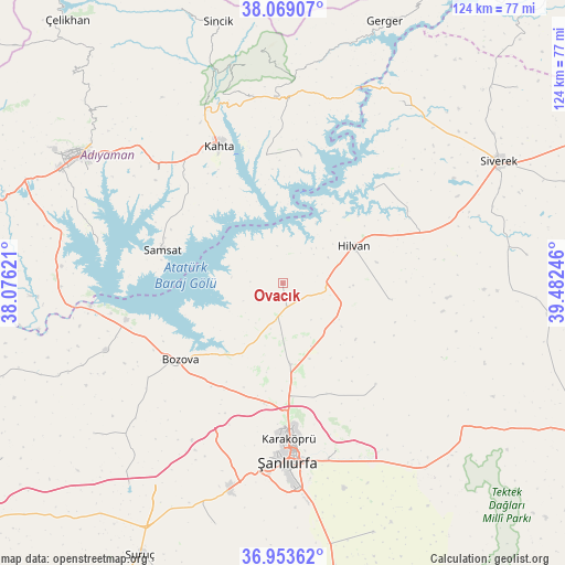
Ovacık GPS coordinates[2]
37° 30' 48.348" North, 38° 46' 45.588" East
| Map corner | latitude | longitude |
|---|---|---|
| Upper-left | 38.06907°, | 38.07621° |
| Center: | 37.51343°, | 38.77933° |
| Lower-right: | 36.95362°, | 39.48246° |
| Map W x H: | 124×124 km | = 77.1×77.1mi |
| max Lat: | 42.02683° ⇑74.3% North |
| Ovacık: | 37.51343° |
| min Lat: | ⇓25.7% South 35.9025° |
| min Long | Ovacık | max Long |
| 25.90902° | 38.77933° | 44.60099° |
| W 65.7%⇐ | ⇒34.3% E |
Elevation
Elevation of Ovacık is 671 m = 2201 ft, and this is 46.4 m = 152 ft below average elevation for this country.
| Max E: |
2682 m = 8799 ft | 51.3% |
| Avg. | 717.4 m = 2354 ft | |
| Ovacık | 671 m = 2201 ft | |
Min E: |
0 m = 0 ft | 48.7% |
See also: Turkey elevation on elevation.city.
Geographical zone
Ovacık is located in North temperate zone (between Tropic of Cancer and the Arctic Circle). Distance of this Northern Tropic circle is 1565.2 km =972.6 mi to South.| Distance of | km | miles | from Ovacık |
|---|---|---|---|
| North Pole | 5836 | 3626.3 | to North |
| Arctic Circle | 3230.1 | 2007.1 | to North |
| Tropic Cancer | 1565.2 | 972.6 | to South |
| Equator | 4171.1 | 2591.8 | to South |


Nearby cities:
15 places around Ovacık: (largest is in red/bold)
• Akziyaret
17.9 km =11.1 mi,  175°
175°
• Akıncılar
28.2 km =17.5 mi,  7°
7°
• Bağpınar
41.5 km =25.8 mi,  282°
282°
• Bozova
27.9 km =17.3 mi,  233°
233°
• Hilvan
17.5 km =10.9 mi,  62°
62°
• Kabahaydar
29.6 km =18.4 mi,  115°
115°
• Kabahaydar
30.2 km =18.8 mi,  137°
137°
• Karaköprü
34.5 km =21.4 mi, 177°
• Kâhta
33.2 km =20.6 mi,  335°
335°
• Narince
41.1 km =25.5 mi,  357°
357°
• Samsat
28 km =17.4 mi,  285°
285°
• Tilfetis
23.9 km =14.9 mi,  98°
98°
• Yaylak
41.5 km =25.8 mi,  249°
249°
• Çaylarbaşı
29 km =18 mi,  44°
44°
• Şanlıurfa
38.5 km =23.9 mi, 178°
Sources, notices
• [Note1] Compared only with cities in Turkey existing in our database
• [Src1] Map data: © OpenStreetMap contributors (CC-BY-SA)
• [Src2] Other city data from geonames.org with taken over terms of usage.
• [Src3] Geographical zone / Annual Mean Temperature by Robert A. Rohde @ Wikipedia
