Aladağ geodata
Aladağ (Adana) is a seat of a second-order administrative division; located in Turkey in Europe/Istanbul (GMT+3) time zone. With population of 7,613 people, there are 590 cities with bigger population in this country. Compared to other cities in Turkey, 73.6% of cities are located further ↑North; 52.6% of cities are located further →East and 60.9% of cities have lower elevation than Aladağ. Note1


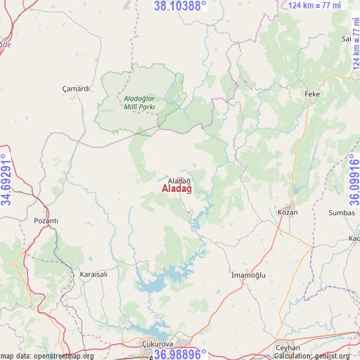
Aladağ GPS coordinates[2]
37° 32' 54.6" North, 35° 23' 45.708" East
| Map corner | latitude | longitude |
|---|---|---|
| Upper-left | 38.10388°, | 34.69291° |
| Center: | 37.5485°, | 35.39603° |
| Lower-right: | 36.98896°, | 36.09916° |
| Map W x H: | 124×124 km | = 77.1×77.1mi |
| max Lat: | 42.02683° ⇑73.6% North |
| Aladağ: | 37.5485° |
| min Lat: | ⇓26.4% South 35.9025° |
| min Long | Aladağ | max Long |
| 25.90902° | 35.39603° | 44.60099° |
| W 47.4%⇐ | ⇒52.6% E |
Elevation
Elevation of Aladağ is 896 m = 2940 ft, and this is 178.6 m = 586 ft above average elevation for this country.
| Max E: |
2682 m = 8799 ft | 39.1% |
| Aladağ | 896 m 2940 ft | |
| Avg. | 717.4 m = 2354 ft | |
Min E: |
0 m = 0 ft | 60.9% |
See also: Turkey elevation on elevation.city.
Geographical zone
Aladağ is located in North temperate zone (between Tropic of Cancer and the Arctic Circle). Distance of this Northern Tropic circle is 1569.1 km =975 mi to South.| Distance of | km | miles | from Aladağ |
|---|---|---|---|
| North Pole | 5832.1 | 3623.9 | to North |
| Arctic Circle | 3226.2 | 2004.7 | to North |
| Tropic Cancer | 1569.1 | 975 | to South |
| Equator | 4175 | 2594.2 | to South |


Nearby cities:
15 places around Aladağ: (largest is in red/bold)
• Adana
61.1 km =38 mi,  185°
185°
• Feke
54.2 km =33.7 mi,  56°
56°
• Kamışlı
39.6 km =24.6 mi,  271°
271°
• Karaisalı
44 km =27.3 mi,  222°
222°
• Kozan
38.4 km =23.9 mi,  105°
105°
• Mansurlu
40.4 km =25.1 mi,  34°
34°
• Pozantı
48.2 km =30 mi,  253°
253°
• Sarıçam
45.2 km =28.1 mi,  167°
167°
• Sağkaya
48.6 km =30.2 mi,  147°
147°
• Sumbas
56.4 km =35 mi,  101°
101°
• Tepecikören
29.1 km =18.1 mi,  135°
135°
• Çamardı
48.2 km =30 mi,  310°
310°
• Çatalan
34.6 km =21.5 mi,  195°
195°
• Çiftehan
55.4 km =34.4 mi, 265°
• İmamoğlu
39.1 km =24.3 mi, 143°
Sources, notices
• [Note1] Compared only with cities in Turkey existing in our database
• [Src1] Map data: © OpenStreetMap contributors (CC-BY-SA)
• [Src2] Other city data from geonames.org with taken over terms of usage.
• [Src3] Geographical zone / Annual Mean Temperature by Robert A. Rohde @ Wikipedia
