Muğla geodata
Muğla is a seat of a first-order administrative division; located in Turkey in Europe/Istanbul (GMT+3) time zone. With population of 48,183 people, there are 179 cities with bigger population in this country. Compared to other cities in Turkey, 82.8% of cities are located further ↑North; 87.9% of cities are located further →East and 51.1% of cities have higher elevation than Muğla. Note1


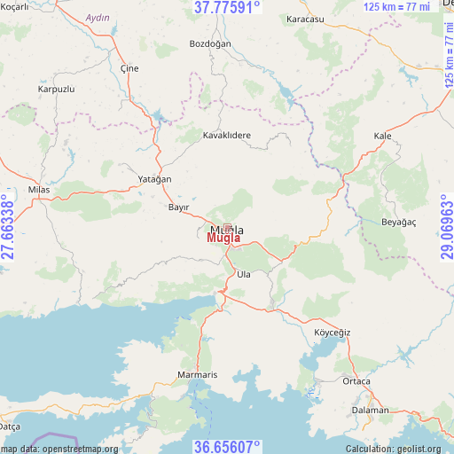
Muğla GPS coordinates[2]
37° 13' 5.052" North, 28° 21' 59.4" East
| Map corner | latitude | longitude |
|---|---|---|
| Upper-left | 37.77591°, | 27.66338° |
| Center: | 37.21807°, | 28.3665° |
| Lower-right: | 36.65607°, | 29.06963° |
| Map W x H: | 124.5×124.5 km | = 77.4×77.4mi |
| max Lat: | 42.02683° ⇑82.8% North |
| Muğla: | 37.21807° |
| min Lat: | ⇓17.2% South 35.9025° |
| min Long | Muğla | max Long |
| 25.90902° | 28.3665° | 44.60099° |
| W 12.1%⇐ | ⇒87.9% E |
Elevation
Elevation of Muğla is 672 m = 2205 ft, and this is 45.4 m = 149 ft below average elevation for this country.
| Max E: |
2682 m = 8799 ft | 51.1% |
| Avg. | 717.4 m = 2354 ft | |
| Muğla | 672 m = 2205 ft | |
Min E: |
0 m = 0 ft | 48.9% |
See also: Muğla elevation on elevation.city.
Geographical zone
Muğla is located in North temperate zone (between Tropic of Cancer and the Arctic Circle). Distance of this Northern Tropic circle is 1532.3 km =952.1 mi to South.| Distance of | km | miles | from Muğla |
|---|---|---|---|
| North Pole | 5868.8 | 3646.7 | to North |
| Arctic Circle | 3262.9 | 2027.5 | to North |
| Tropic Cancer | 1532.3 | 952.1 | to South |
| Equator | 4138.3 | 2571.4 | to South |


Nearby cities:
15 places around Muğla: (largest is in red/bold)
• Akçaova
43.6 km =27.1 mi,  316°
316°
• Bayır
14.4 km =8.9 mi,  292°
292°
• Beyağaç
46.9 km =29.1 mi,  87°
87°
• Bozarmut
20.1 km =12.5 mi,  300°
300°
• Göktepe
28.1 km =17.5 mi,  37°
37°
• Kale
49 km =30.4 mi,  59°
59°
• Kavaklıdere
25.2 km =15.7 mi,  359°
359°
• Marmaris
41.2 km =25.6 mi,  191°
191°
• Menteşe
14.3 km =8.9 mi,  218°
218°
• Turgut
34.4 km =21.4 mi, 300°
• Ula
13.3 km =8.3 mi,  160°
160°
• Yatağan
24 km =14.9 mi, 304°
• Yerkesik
11.7 km =7.3 mi, 218°
• Yeşilyurt
8.5 km =5.3 mi,  251°
251°
• Ören
40.8 km =25.4 mi,  240°
240°
Sources, notices
• [Note1] Compared only with cities in Turkey existing in our database
• [Src1] Map data: © OpenStreetMap contributors (CC-BY-SA)
• [Src2] Other city data from geonames.org with taken over terms of usage.
• [Src3] Geographical zone / Annual Mean Temperature by Robert A. Rohde @ Wikipedia
