Göktepe geodata
Göktepe (Muğla) is a seat of a third-order administrative division; located in Turkey in Europe/Istanbul (GMT+3) time zone. In our database, there are 1323 cities with bigger population. Compared to other cities in Turkey, 77.1% of cities are located further ↑North; 86.8% of cities are located further →East and 61.6% of cities have higher elevation than Göktepe. Note1


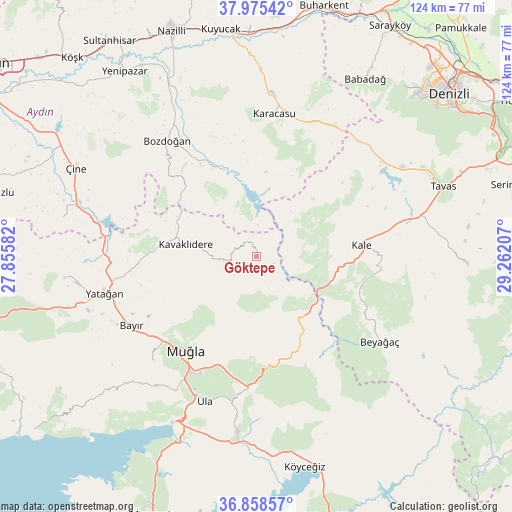
Göktepe GPS coordinates[2]
37° 25' 8.688" North, 28° 33' 32.184" East
| Map corner | latitude | longitude |
|---|---|---|
| Upper-left | 37.97542°, | 27.85582° |
| Center: | 37.41908°, | 28.55894° |
| Lower-right: | 36.85857°, | 29.26207° |
| Map W x H: | 124.2×124.2 km | = 77.2×77.2mi |
| max Lat: | 42.02683° ⇑77.1% North |
| Göktepe: | 37.41908° |
| min Lat: | ⇓22.9% South 35.9025° |
| min Long | Göktepe | max Long |
| 25.90902° | 28.55894° | 44.60099° |
| W 13.2%⇐ | ⇒86.8% E |
Elevation
Elevation of Göktepe is 483 m = 1585 ft, and this is 234.4 m = 769 ft below average elevation for this country.
| Max E: |
2682 m = 8799 ft | 61.6% |
| Avg. | 717.4 m = 2354 ft | |
| Göktepe | 483 m = 1585 ft | |
Min E: |
0 m = 0 ft | 38.4% |
See also: Turkey elevation on elevation.city.
Geographical zone
Göktepe is located in North temperate zone (between Tropic of Cancer and the Arctic Circle). Distance of this Northern Tropic circle is 1554.7 km =966 mi to South.| Distance of | km | miles | from Göktepe |
|---|---|---|---|
| North Pole | 5846.5 | 3632.8 | to North |
| Arctic Circle | 3240.6 | 2013.6 | to North |
| Tropic Cancer | 1554.7 | 966 | to South |
| Equator | 4160.6 | 2585.3 | to South |


Nearby cities:
15 places around Göktepe: (largest is in red/bold)
• Bayır
34.6 km =21.5 mi,  240°
240°
• Beyağaç
36.1 km =22.4 mi,  124°
124°
• Bozarmut
36.5 km =22.7 mi,  250°
250°
• Bozdoğan
35.4 km =22 mi,  322°
322°
• Kale
25.4 km =15.8 mi,  84°
84°
• Karacasu
34.6 km =21.5 mi,  6°
6°
• Kavaklıdere
17.6 km =10.9 mi,  279°
279°
• Kızılcabölük
45.8 km =28.5 mi,  62°
62°
• Menteşe
42.4 km =26.3 mi,  217°
217°
• Muğla
28.1 km =17.5 mi, 217°
• Ula
37.1 km =23.1 mi,  199°
199°
• Yatağan
37.8 km =23.5 mi,  256°
256°
• Yenice
45.5 km =28.3 mi,  1°
1°
• Yerkesik
39.8 km =24.7 mi, 217°
• Yeşilyurt
35.5 km =22.1 mi, 224°
Sources, notices
• [Note1] Compared only with cities in Turkey existing in our database
• [Src1] Map data: © OpenStreetMap contributors (CC-BY-SA)
• [Src2] Other city data from geonames.org with taken over terms of usage.
• [Src3] Geographical zone / Annual Mean Temperature by Robert A. Rohde @ Wikipedia
