İmamoğlu geodata
İmamoğlu (Adana) is a seat of a second-order administrative division; located in Turkey in Europe/Istanbul (GMT+3) time zone. With population of 31,916 people, there are 240 cities with bigger population in this country. Compared to other cities in Turkey, 81.3% of cities are located further ↑North; 51.2% of cities are located further →East and 83.1% of cities have higher elevation than İmamoğlu. Note1


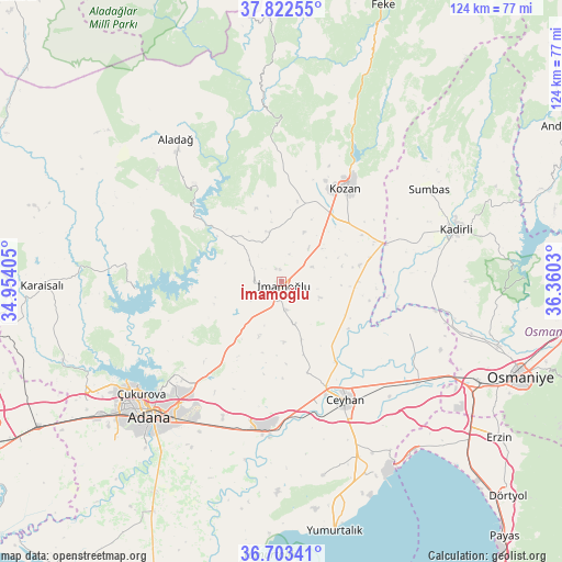
İmamoğlu GPS coordinates[2]
37° 15' 54.216" North, 35° 39' 25.812" East
| Map corner | latitude | longitude |
|---|---|---|
| Upper-left | 37.82255°, | 34.95405° |
| Center: | 37.26506°, | 35.65717° |
| Lower-right: | 36.70341°, | 36.3603° |
| Map W x H: | 124.4×124.4 km | = 77.3×77.3mi |
| max Lat: | 42.02683° ⇑81.3% North |
| İmamoğlu: | 37.26506° |
| min Lat: | ⇓18.7% South 35.9025° |
| min Long | İmamoğlu | max Long |
| 25.90902° | 35.65717° | 44.60099° |
| W 48.8%⇐ | ⇒51.2% E |
Elevation
Elevation of İmamoğlu is 85 m = 279 ft, and this is 632.4 m = 2075 ft below average elevation for this country.
| Max E: |
2682 m = 8799 ft | 83.1% |
| Avg. | 717.4 m = 2354 ft | |
| İmamoğlu | 85 m = 279 ft | |
Min E: |
0 m = 0 ft | 16.9% |
See also: Turkey elevation on elevation.city.
Geographical zone
İmamoğlu is located in North temperate zone (between Tropic of Cancer and the Arctic Circle). Distance of this Northern Tropic circle is 1537.6 km =955.4 mi to South.| Distance of | km | miles | from İmamoğlu |
|---|---|---|---|
| North Pole | 5863.6 | 3643.5 | to North |
| Arctic Circle | 3257.7 | 2024.2 | to North |
| Tropic Cancer | 1537.6 | 955.4 | to South |
| Equator | 4143.5 | 2574.7 | to South |


Nearby cities:
15 places around İmamoğlu: (largest is in red/bold)
• Adana
41.3 km =25.7 mi,  224°
224°
• Aladağ
39.1 km =24.3 mi,  323°
323°
• Ceyhan
30.3 km =18.8 mi,  151°
151°
• Kadirli
40.7 km =25.3 mi,  72°
72°
• Kozan
25.4 km =15.8 mi,  33°
33°
• Kösreli
30.6 km =19 mi,  111°
111°
• Sarıçam
18.3 km =11.4 mi,  226°
226°
• Sağkaya
10 km =6.2 mi,  163°
163°
• Seyhan
43.8 km =27.2 mi, 225°
• Sumbas
38.4 km =23.9 mi,  57°
57°
• Tecirli
41.7 km =25.9 mi, 105°
• Tepecikören
11 km =6.8 mi,  345°
345°
• Yakapınar
32.6 km =20.3 mi,  185°
185°
• Yüreğir
41.7 km =25.9 mi, 219°
• Çatalan
32.4 km =20.1 mi,  266°
266°
Sources, notices
• [Note1] Compared only with cities in Turkey existing in our database
• [Src1] Map data: © OpenStreetMap contributors (CC-BY-SA)
• [Src2] Other city data from geonames.org with taken over terms of usage.
• [Src3] Geographical zone / Annual Mean Temperature by Robert A. Rohde @ Wikipedia
