Sarıgöl geodata
Sarıgöl (Manisa) is a seat of a second-order administrative division; located in Turkey in Europe/Istanbul (GMT+3) time zone. With population of 12,794 people, there are 436 cities with bigger population in this country. Compared to other cities in Turkey, 57.4% of cities are located further ↑North; 85.8% of cities are located further →East and 73% of cities have higher elevation than Sarıgöl. Note1


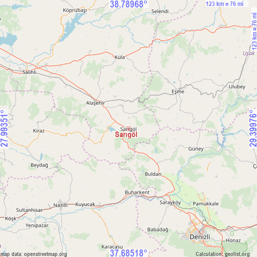
Sarıgöl GPS coordinates[2]
38° 14' 22.308" North, 28° 41' 47.868" East
| Map corner | latitude | longitude |
|---|---|---|
| Upper-left | 38.78968°, | 27.99351° |
| Center: | 38.23953°, | 28.69663° |
| Lower-right: | 37.68518°, | 29.39976° |
| Map W x H: | 122.8×122.8 km | = 76.3×76.3mi |
| max Lat: | 42.02683° ⇑57.4% North |
| Sarıgöl: | 38.23953° |
| min Lat: | ⇓42.6% South 35.9025° |
| min Long | Sarıgöl | max Long |
| 25.90902° | 28.69663° | 44.60099° |
| W 14.2%⇐ | ⇒85.8% E |
Elevation
Elevation of Sarıgöl is 214 m = 702 ft, and this is 503.4 m = 1652 ft below average elevation for this country.
| Max E: |
2682 m = 8799 ft | 73% |
| Avg. | 717.4 m = 2354 ft | |
| Sarıgöl | 214 m = 702 ft | |
Min E: |
0 m = 0 ft | 27% |
See also: Turkey elevation on elevation.city.
Geographical zone
Sarıgöl is located in North temperate zone (between Tropic of Cancer and the Arctic Circle). Distance of this Northern Tropic circle is 1645.9 km =1022.7 mi to South.| Distance of | km | miles | from Sarıgöl |
|---|---|---|---|
| North Pole | 5755.2 | 3576.1 | to North |
| Arctic Circle | 3149.3 | 1956.9 | to North |
| Tropic Cancer | 1645.9 | 1022.7 | to South |
| Equator | 4251.8 | 2641.9 | to South |


Nearby cities:
15 places around Sarıgöl: (largest is in red/bold)
• Alaşehir
20 km =12.4 mi,  308°
308°
• Buharkent
30.9 km =19.2 mi,  172°
172°
• Buldan
24.6 km =15.3 mi,  151°
151°
• Eşme
29.7 km =18.5 mi,  53°
53°
• Gözler
42.6 km =26.5 mi,  110°
110°
• Güllü
35.8 km =22.2 mi,  84°
84°
• Güney
33.8 km =21 mi, 106°
• Horsunlu
37.3 km =23.2 mi,  194°
194°
• Kiraz
43 km =26.7 mi,  268°
268°
• Kula
34.5 km =21.4 mi,  353°
353°
• Kuyucak
41.8 km =26 mi,  209°
209°
• Menye
41.5 km =25.8 mi,  334°
334°
• Pamukören
37.7 km =23.4 mi,  201°
201°
• Sarayköy
40.3 km =25 mi, 150°
• Yeşilyurt
11.5 km =7.1 mi, 345°
Sources, notices
• [Note1] Compared only with cities in Turkey existing in our database
• [Src1] Map data: © OpenStreetMap contributors (CC-BY-SA)
• [Src2] Other city data from geonames.org with taken over terms of usage.
• [Src3] Geographical zone / Annual Mean Temperature by Robert A. Rohde @ Wikipedia
