Hasançelebi geodata
Hasançelebi (Malatya) is a seat of a third-order administrative division; located in Turkey in Europe/Istanbul (GMT+3) time zone. In our database, there are 1323 cities with bigger population. Compared to other cities in Turkey, 53.8% of cities are located further ↓South; 61.1% of cities are located further ←West and 88.6% of cities have lower elevation than Hasançelebi. Note1


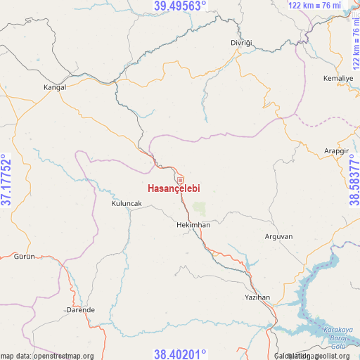
Hasançelebi GPS coordinates[2]
38° 57' 3.348" North, 37° 52' 50.304" East
| Map corner | latitude | longitude |
|---|---|---|
| Upper-left | 39.49563°, | 37.17752° |
| Center: | 38.95093°, | 37.88064° |
| Lower-right: | 38.40201°, | 38.58377° |
| Map W x H: | 121.6×121.6 km | = 75.6×75.6mi |
| max Lat: | 42.02683° ⇑46.2% North |
| Hasançelebi: | 38.95093° |
| min Lat: | ⇓53.8% South 35.9025° |
| min Long | Hasançelebi | max Long |
| 25.90902° | 37.88064° | 44.60099° |
| W 61.1%⇐ | ⇒38.9% E |
Elevation
Elevation of Hasançelebi is 1416 m = 4646 ft, and this is 698.6 m = 2292 ft above average elevation for this country.
| Max E: |
2682 m = 8799 ft | 11.4% |
| Hasançelebi | 1416 m 4646 ft | |
| Avg. | 717.4 m = 2354 ft | |
Min E: |
0 m = 0 ft | 88.6% |
See also: Turkey elevation on elevation.city.
Geographical zone
Hasançelebi is located in North temperate zone (between Tropic of Cancer and the Arctic Circle). Distance of this Northern Tropic circle is 1725 km =1071.9 mi to South.| Distance of | km | miles | from Hasançelebi |
|---|---|---|---|
| North Pole | 5676.1 | 3527 | to North |
| Arctic Circle | 3070.2 | 1907.7 | to North |
| Tropic Cancer | 1725 | 1071.9 | to South |
| Equator | 4330.9 | 2691.1 | to South |


Nearby cities:
15 places around Hasançelebi: (largest is in red/bold)
• Alacahan
31.5 km =19.6 mi,  303°
303°
• Arguvan
38.5 km =23.9 mi,  120°
120°
• Danişment
36.8 km =22.9 mi,  48°
48°
• Divriği
50.8 km =31.6 mi,  23°
23°
• Hekimhan
15.5 km =9.6 mi,  164°
164°
• Kale
13.8 km =8.6 mi, 48°
• Kangal
52.7 km =32.7 mi,  306°
306°
• Kavak
51.2 km =31.8 mi,  317°
317°
• Konakpınar
50.7 km =31.5 mi,  264°
264°
• Kuluncak
20.6 km =12.8 mi,  246°
246°
• Kurşunlu
33.2 km =20.6 mi,  184°
184°
• Mursal
25 km =15.5 mi, 15°
• Yazıhan
47.2 km =29.3 mi,  147°
147°
• Yoncalı
32.8 km =20.4 mi,  78°
78°
• Çetinkaya
41 km =25.5 mi,  327°
327°
Sources, notices
• [Note1] Compared only with cities in Turkey existing in our database
• [Src1] Map data: © OpenStreetMap contributors (CC-BY-SA)
• [Src2] Other city data from geonames.org with taken over terms of usage.
• [Src3] Geographical zone / Annual Mean Temperature by Robert A. Rohde @ Wikipedia
