Kurşunlu geodata
Kurşunlu (Malatya) is a seat of a second-order administrative division; located in Turkey in Europe/Istanbul (GMT+3) time zone. In our database, there are 1323 cities with bigger population. Compared to other cities in Turkey, 50.7% of cities are located further ↑North; 60.8% of cities are located further ←West and 91.7% of cities have lower elevation than Kurşunlu. Note1


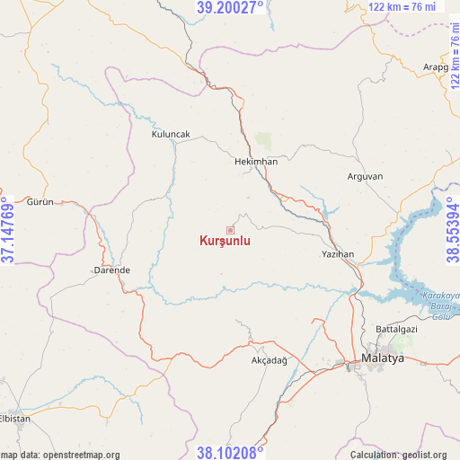
Kurşunlu GPS coordinates[2]
38° 39' 11.808" North, 37° 51' 2.916" East
| Map corner | latitude | longitude |
|---|---|---|
| Upper-left | 39.20027°, | 37.14769° |
| Center: | 38.65328°, | 37.85081° |
| Lower-right: | 38.10208°, | 38.55394° |
| Map W x H: | 122.1×122.1 km | = 75.9×75.9mi |
| max Lat: | 42.02683° ⇑50.7% North |
| Kurşunlu: | 38.65328° |
| min Lat: | ⇓49.3% South 35.9025° |
| min Long | Kurşunlu | max Long |
| 25.90902° | 37.85081° | 44.60099° |
| W 60.8%⇐ | ⇒39.2% E |
Elevation
Elevation of Kurşunlu is 1531 m = 5023 ft, and this is 813.6 m = 2669 ft above average elevation for this country.
| Max E: |
2682 m = 8799 ft | 8.3% |
| Kurşunlu | 1531 m 5023 ft | |
| Avg. | 717.4 m = 2354 ft | |
Min E: |
0 m = 0 ft | 91.7% |
See also: Turkey elevation on elevation.city.
Geographical zone
Kurşunlu is located in North temperate zone (between Tropic of Cancer and the Arctic Circle). Distance of this Northern Tropic circle is 1691.9 km =1051.3 mi to South.| Distance of | km | miles | from Kurşunlu |
|---|---|---|---|
| North Pole | 5709.2 | 3547.5 | to North |
| Arctic Circle | 3103.3 | 1928.3 | to North |
| Tropic Cancer | 1691.9 | 1051.3 | to South |
| Equator | 4297.8 | 2670.5 | to South |


Nearby cities:
15 places around Kurşunlu: (largest is in red/bold)
• Akçadağ
36.5 km =22.7 mi,  163°
163°
• Arguvan
38.2 km =23.7 mi,  69°
69°
• Balaban
31.9 km =19.8 mi,  227°
227°
• Battalgazi
51 km =31.7 mi,  120°
120°
• Darende
32.3 km =20.1 mi,  248°
248°
• Gürün
50.9 km =31.6 mi,  278°
278°
• Hasançelebi
33.2 km =20.6 mi,  4°
4°
• Hekimhan
19.3 km =12 mi,  20°
20°
• Kale
44.2 km =27.5 mi, 17°
• Kuluncak
29.7 km =18.5 mi,  326°
326°
• Kürecik
36.5 km =22.7 mi,  195°
195°
• Levent
24 km =14.9 mi,  179°
179°
• Yazıhan
28.8 km =17.9 mi,  103°
103°
• Yeşilyurt
52.5 km =32.6 mi,  139°
139°
• Yoncalı
52.7 km =32.7 mi,  41°
41°
Sources, notices
• [Note1] Compared only with cities in Turkey existing in our database
• [Src1] Map data: © OpenStreetMap contributors (CC-BY-SA)
• [Src2] Other city data from geonames.org with taken over terms of usage.
• [Src3] Geographical zone / Annual Mean Temperature by Robert A. Rohde @ Wikipedia
