Esençay geodata
Esençay (Amasya) is a seat of a third-order administrative division; located in Turkey in Europe/Istanbul (GMT+3) time zone. In our database, there are 1323 cities with bigger population. Compared to other cities in Turkey, 80.3% of cities are located further ↓South; 54% of cities are located further ←West and 56% of cities have higher elevation than Esençay. Note1


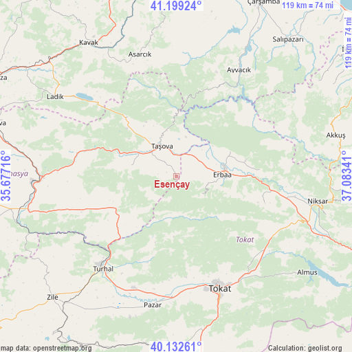
Esençay GPS coordinates[2]
40° 40' 5.016" North, 36° 22' 49.008" East
| Map corner | latitude | longitude |
|---|---|---|
| Upper-left | 41.19924°, | 35.67716° |
| Center: | 40.66806°, | 36.38028° |
| Lower-right: | 40.13261°, | 37.08341° |
| Map W x H: | 118.6×118.6 km | = 73.7×73.7mi |
| max Lat: | 42.02683° ⇑19.7% North |
| Esençay: | 40.66806° |
| min Lat: | ⇓80.3% South 35.9025° |
| min Long | Esençay | max Long |
| 25.90902° | 36.38028° | 44.60099° |
| W 54%⇐ | ⇒46% E |
Elevation
Elevation of Esençay is 569 m = 1867 ft, and this is 148.4 m = 487 ft below average elevation for this country.
| Max E: |
2682 m = 8799 ft | 56% |
| Avg. | 717.4 m = 2354 ft | |
| Esençay | 569 m = 1867 ft | |
Min E: |
0 m = 0 ft | 44% |
See also: Turkey elevation on elevation.city.
Geographical zone
Esençay is located in North temperate zone (between Tropic of Cancer and the Arctic Circle). Distance of this Northern Tropic circle is 1915.9 km =1190.5 mi to South.| Distance of | km | miles | from Esençay |
|---|---|---|---|
| North Pole | 5485.2 | 3408.3 | to North |
| Arctic Circle | 2879.3 | 1789.1 | to North |
| Tropic Cancer | 1915.9 | 1190.5 | to South |
| Equator | 4521.9 | 2809.8 | to South |


Nearby cities:
15 places around Esençay: (largest is in red/bold)
• Akdağ
34.4 km =21.4 mi,  278°
278°
• Destek
25.9 km =16.1 mi,  320°
320°
• Doğanyurt
28.4 km =17.6 mi,  85°
85°
• Dökmetepe
40.3 km =25 mi,  190°
190°
• Erbaa
15.8 km =9.8 mi, 89°
• Ezinepazarı
23.1 km =14.4 mi,  241°
241°
• Gökdere
38.2 km =23.7 mi,  124°
124°
• Gökçeli
31.2 km =19.4 mi,  107°
107°
• Karayaka
19.6 km =12.2 mi,  64°
64°
• Kozlu
10.6 km =6.6 mi,  128°
128°
• Taşova
11.3 km =7 mi,  334°
334°
• Tekke
16.7 km =10.4 mi,  288°
288°
• Turhal
40.2 km =25 mi,  219°
219°
• Yeşilyurt
37.9 km =23.5 mi,  183°
183°
• Şeyhli
38.8 km =24.1 mi, 316°
Sources, notices
• [Note1] Compared only with cities in Turkey existing in our database
• [Src1] Map data: © OpenStreetMap contributors (CC-BY-SA)
• [Src2] Other city data from geonames.org with taken over terms of usage.
• [Src3] Geographical zone / Annual Mean Temperature by Robert A. Rohde @ Wikipedia
