Bayat geodata
Bayat (Çorum) is a seat of a second-order administrative division; located in Turkey in Europe/Istanbul (GMT+3) time zone. In our database, there are 1323 cities with bigger population. Compared to other cities in Turkey, 79.9% of cities are located further ↓South; 57.5% of cities are located further →East and 50.4% of cities have lower elevation than Bayat. Note1


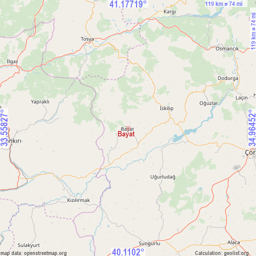
Bayat GPS coordinates[2]
40° 38' 44.988" North, 34° 15' 41.004" East
| Map corner | latitude | longitude |
|---|---|---|
| Upper-left | 41.17719°, | 33.55827° |
| Center: | 40.64583°, | 34.26139° |
| Lower-right: | 40.1102°, | 34.96452° |
| Map W x H: | 118.6×118.6 km | = 73.7×73.7mi |
| max Lat: | 42.02683° ⇑20.1% North |
| Bayat: | 40.64583° |
| min Lat: | ⇓79.9% South 35.9025° |
| min Long | Bayat | max Long |
| 25.90902° | 34.26139° | 44.60099° |
| W 42.5%⇐ | ⇒57.5% E |
Elevation
Elevation of Bayat is 698 m = 2290 ft, and this is 19.4 m = 64 ft below average elevation for this country.
| Max E: |
2682 m = 8799 ft | 49.6% |
| Avg. | 717.4 m = 2354 ft | |
| Bayat | 698 m = 2290 ft | |
Min E: |
0 m = 0 ft | 50.4% |
See also: Turkey elevation on elevation.city.
Geographical zone
Bayat is located in North temperate zone (between Tropic of Cancer and the Arctic Circle). Distance of this Northern Tropic circle is 1913.5 km =1189 mi to South.| Distance of | km | miles | from Bayat |
|---|---|---|---|
| North Pole | 5487.7 | 3409.9 | to North |
| Arctic Circle | 2881.8 | 1790.7 | to North |
| Tropic Cancer | 1913.5 | 1189 | to South |
| Equator | 4519.4 | 2808.2 | to South |


Nearby cities:
15 places around Bayat: (largest is in red/bold)
• Dodurga
51.5 km =32 mi,  63°
63°
• Hacıhamza
50.2 km =31.2 mi,  18°
18°
• Kargı
57.5 km =35.7 mi, 19°
• Khanjarah
54.8 km =34.1 mi,  264°
264°
• Kızılırmak
40.7 km =25.3 mi,  214°
214°
• Laçin
54.1 km =33.6 mi,  74°
74°
• Osmancık
58.8 km =36.5 mi,  51°
51°
• Oğuzlar
39.1 km =24.3 mi, 72°
• Seydim
41.8 km =26 mi,  105°
105°
• Sungurlu
54 km =33.6 mi,  169°
169°
• Tosya
45.1 km =28 mi,  335°
335°
• Uğurludağ
27.4 km =17 mi,  143°
143°
• Yapraklı
42.6 km =26.5 mi,  287°
287°
• İkizören
32.2 km =20 mi,  278°
278°
• İskilip
20.5 km =12.7 mi, 60°
Sources, notices
• [Note1] Compared only with cities in Turkey existing in our database
• [Src1] Map data: © OpenStreetMap contributors (CC-BY-SA)
• [Src2] Other city data from geonames.org with taken over terms of usage.
• [Src3] Geographical zone / Annual Mean Temperature by Robert A. Rohde @ Wikipedia
