Tortum geodata
Tortum (Erzurum) is a seat of a second-order administrative division; located in Turkey in Europe/Istanbul (GMT+3) time zone. With population of 9,429 people, there are 523 cities with bigger population in this country. Compared to other cities in Turkey, 74.3% of cities are located further ↓South; 86.6% of cities are located further ←West and 97.6% of cities have lower elevation than Tortum. Note1


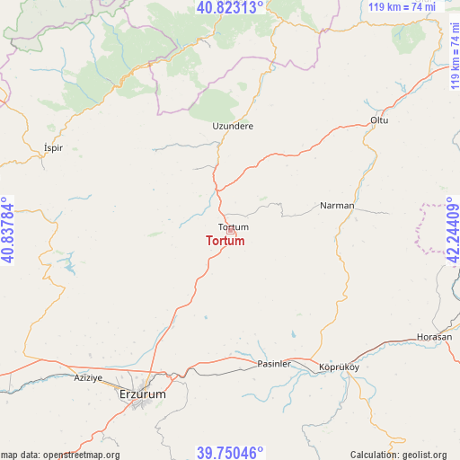
Tortum GPS coordinates[2]
40° 17' 20.112" North, 41° 32' 27.456" East
| Map corner | latitude | longitude |
|---|---|---|
| Upper-left | 40.82313°, | 40.83784° |
| Center: | 40.28892°, | 41.54096° |
| Lower-right: | 39.75046°, | 42.24409° |
| Map W x H: | 119.3×119.3 km | = 74.1×74.1mi |
| max Lat: | 42.02683° ⇑25.7% North |
| Tortum: | 40.28892° |
| min Lat: | ⇓74.3% South 35.9025° |
| min Long | Tortum | max Long |
| 25.90902° | 41.54096° | 44.60099° |
| W 86.6%⇐ | ⇒13.4% E |
Elevation
Elevation of Tortum is 1819 m = 5968 ft, and this is 1101.6 m = 3614 ft above average elevation for this country.
| Max E: |
2682 m = 8799 ft | 2.4% |
| Tortum | 1819 m 5968 ft | |
| Avg. | 717.4 m = 2354 ft | |
Min E: |
0 m = 0 ft | 97.6% |
See also: Turkey elevation on elevation.city.
Geographical zone
Tortum is located in North temperate zone (between Tropic of Cancer and the Arctic Circle). Distance of this Northern Tropic circle is 1873.8 km =1164.3 mi to South.| Distance of | km | miles | from Tortum |
|---|---|---|---|
| North Pole | 5527.4 | 3434.6 | to North |
| Arctic Circle | 2921.5 | 1815.3 | to North |
| Tropic Cancer | 1873.8 | 1164.3 | to South |
| Equator | 4479.7 | 2783.6 | to South |


Nearby cities:
15 places around Tortum: (largest is in red/bold)
• Dadaşköy
45.3 km =28.1 mi,  212°
212°
• Dumlu
30 km =18.6 mi, 211°
• Erzurum
47.9 km =29.8 mi, 207°
• Kazımkarabekir
47 km =29.2 mi, 208°
• Köprüköy
45.4 km =28.2 mi,  142°
142°
• Kılıçkaya
46.6 km =29 mi,  353°
353°
• Kışlaköy
41 km =25.5 mi,  84°
84°
• Narman
27.8 km =17.3 mi, 77°
• Oltu
46.9 km =29.1 mi,  53°
53°
• Ovacık
47.2 km =29.3 mi,  257°
257°
• Palandöken
49.7 km =30.9 mi, 206°
• Pasinler
36.1 km =22.4 mi,  162°
162°
• Uzundere
27 km =16.8 mi,  359°
359°
• Yakutiye
49.2 km =30.6 mi, 208°
• Şenyurt
18 km =11.2 mi,  328°
328°
Sources, notices
• [Note1] Compared only with cities in Turkey existing in our database
• [Src1] Map data: © OpenStreetMap contributors (CC-BY-SA)
• [Src2] Other city data from geonames.org with taken over terms of usage.
• [Src3] Geographical zone / Annual Mean Temperature by Robert A. Rohde @ Wikipedia
