Şenyurt geodata
Şenyurt (Erzurum) is a seat of a third-order administrative division; located in Turkey in Europe/Istanbul (GMT+3) time zone. In our database, there are 1323 cities with bigger population. Compared to other cities in Turkey, 76.6% of cities are located further ↓South; 85.7% of cities are located further ←West and 90.9% of cities have lower elevation than Şenyurt. Note1


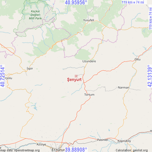
Şenyurt GPS coordinates[2]
40° 25' 35.22" North, 41° 25' 41.736" East
| Map corner | latitude | longitude |
|---|---|---|
| Upper-left | 40.95956°, | 40.72514° |
| Center: | 40.42645°, | 41.42826° |
| Lower-right: | 39.88908°, | 42.13139° |
| Map W x H: | 119×119 km | = 73.9×73.9mi |
| max Lat: | 42.02683° ⇑23.4% North |
| Şenyurt: | 40.42645° |
| min Lat: | ⇓76.6% South 35.9025° |
| min Long | Şenyurt | max Long |
| 25.90902° | 41.42826° | 44.60099° |
| W 85.7%⇐ | ⇒14.3% E |
Elevation
Elevation of Şenyurt is 1505 m = 4938 ft, and this is 787.6 m = 2584 ft above average elevation for this country.
| Max E: |
2682 m = 8799 ft | 9.1% |
| Şenyurt | 1505 m 4938 ft | |
| Avg. | 717.4 m = 2354 ft | |
Min E: |
0 m = 0 ft | 90.9% |
See also: Turkey elevation on elevation.city.
Geographical zone
Şenyurt is located in North temperate zone (between Tropic of Cancer and the Arctic Circle). Distance of this Northern Tropic circle is 1889.1 km =1173.8 mi to South.| Distance of | km | miles | from Şenyurt |
|---|---|---|---|
| North Pole | 5512.1 | 3425.1 | to North |
| Arctic Circle | 2906.2 | 1805.8 | to North |
| Tropic Cancer | 1889.1 | 1173.8 | to South |
| Equator | 4495 | 2793.1 | to South |


Nearby cities:
15 places around Şenyurt: (largest is in red/bold)
• Dadaşköy
55.5 km =34.5 mi,  195°
195°
• Dumlu
41.3 km =25.7 mi,  188°
188°
• Kılıçkaya
31.2 km =19.4 mi,  7°
7°
• Kırık
44.5 km =27.7 mi,  255°
255°
• Kışlaköy
51.6 km =32.1 mi,  102°
102°
• Narman
37.8 km =23.5 mi, 103°
• Oltu
48.9 km =30.4 mi,  75°
75°
• Ovacık
44.3 km =27.5 mi,  235°
235°
• Pasinler
53.7 km =33.4 mi,  157°
157°
• Pazaryolu
55.9 km =34.7 mi,  268°
268°
• Tortum
18 km =11.2 mi,  148°
148°
• Uzundere
15 km =9.3 mi,  38°
38°
• Yusufeli
44.8 km =27.8 mi, 11°
• Çamlıkaya
33.2 km =20.6 mi,  315°
315°
• İspir
37.2 km =23.1 mi,  279°
279°
Sources, notices
• [Note1] Compared only with cities in Turkey existing in our database
• [Src1] Map data: © OpenStreetMap contributors (CC-BY-SA)
• [Src2] Other city data from geonames.org with taken over terms of usage.
• [Src3] Geographical zone / Annual Mean Temperature by Robert A. Rohde @ Wikipedia
