Kışlaköy geodata
Kışlaköy (Erzurum) is a seat of a third-order administrative division; located in Turkey in Europe/Istanbul (GMT+3) time zone. In our database, there are 1323 cities with bigger population. Compared to other cities in Turkey, 74.7% of cities are located further ↓South; 90.6% of cities are located further ←West and 98.6% of cities have lower elevation than Kışlaköy. Note1


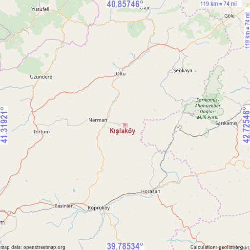
Kışlaköy GPS coordinates[2]
40° 19' 24.708" North, 42° 1' 20.388" East
| Map corner | latitude | longitude |
|---|---|---|
| Upper-left | 40.85746°, | 41.31921° |
| Center: | 40.32353°, | 42.02233° |
| Lower-right: | 39.78534°, | 42.72546° |
| Map W x H: | 119.2×119.2 km | = 74.1×74.1mi |
| max Lat: | 42.02683° ⇑25.3% North |
| Kışlaköy: | 40.32353° |
| min Lat: | ⇓74.7% South 35.9025° |
| min Long | Kışlaköy | max Long |
| 25.90902° | 42.02233° | 44.60099° |
| W 90.6%⇐ | ⇒9.4% E |
Elevation
Elevation of Kışlaköy is 1924 m = 6312 ft, and this is 1206.6 m = 3959 ft above average elevation for this country.
| Max E: |
2682 m = 8799 ft | 1.4% |
| Kışlaköy | 1924 m 6312 ft | |
| Avg. | 717.4 m = 2354 ft | |
Min E: |
0 m = 0 ft | 98.6% |
See also: Turkey elevation on elevation.city.
Geographical zone
Kışlaköy is located in North temperate zone (between Tropic of Cancer and the Arctic Circle). Distance of this Northern Tropic circle is 1877.6 km =1166.7 mi to South.| Distance of | km | miles | from Kışlaköy |
|---|---|---|---|
| North Pole | 5523.5 | 3432.1 | to North |
| Arctic Circle | 2917.6 | 1812.9 | to North |
| Tropic Cancer | 1877.6 | 1166.7 | to South |
| Equator | 4483.6 | 2786 | to South |


Nearby cities:
15 places around Kışlaköy: (largest is in red/bold)
• Akşar
44.8 km =27.8 mi,  36°
36°
• Aras
44.4 km =27.6 mi,  147°
147°
• Gaziler
29.7 km =18.5 mi,  68°
68°
• Horasan
33.9 km =21.1 mi,  159°
159°
• Karaurgan
23.2 km =14.4 mi,  113°
113°
• Kömürlü
51 km =31.7 mi,  26°
26°
• Köprüköy
41.9 km =26 mi,  198°
198°
• Narman
13.9 km =8.6 mi,  279°
279°
• Oltu
24.2 km =15 mi,  352°
352°
• Pasinler
48.6 km =30.2 mi,  218°
218°
• Sarıkamış
47.9 km =29.8 mi,  89°
89°
• Tortum
41 km =25.5 mi,  264°
264°
• Uzundere
47.1 km =29.3 mi,  299°
299°
• Çiftlik
34.3 km =21.3 mi,  144°
144°
• Şenkaya
37.5 km =23.3 mi,  46°
46°
Sources, notices
• [Note1] Compared only with cities in Turkey existing in our database
• [Src1] Map data: © OpenStreetMap contributors (CC-BY-SA)
• [Src2] Other city data from geonames.org with taken over terms of usage.
• [Src3] Geographical zone / Annual Mean Temperature by Robert A. Rohde @ Wikipedia
