Ovacık geodata
Ovacık (Erzurum) is a seat of a second-order administrative division; located in Turkey in Europe/Istanbul (GMT+3) time zone. In our database, there are 1323 cities with bigger population. Compared to other cities in Turkey, 72.5% of cities are located further ↓South; 81.3% of cities are located further ←West and 99.8% of cities have lower elevation than Ovacık. Note1


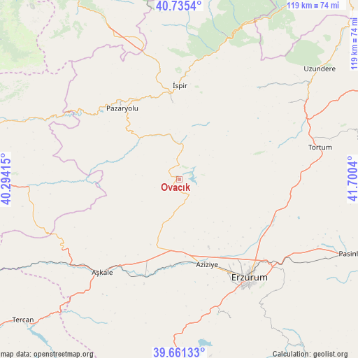
Ovacık GPS coordinates[2]
40° 12' 1.764" North, 40° 59' 50.172" East
| Map corner | latitude | longitude |
|---|---|---|
| Upper-left | 40.7354°, | 40.29415° |
| Center: | 40.20049°, | 40.99727° |
| Lower-right: | 39.66133°, | 41.7004° |
| Map W x H: | 119.4×119.4 km | = 74.2×74.2mi |
| max Lat: | 42.02683° ⇑27.5% North |
| Ovacık: | 40.20049° |
| min Lat: | ⇓72.5% South 35.9025° |
| min Long | Ovacık | max Long |
| 25.90902° | 40.99727° | 44.60099° |
| W 81.3%⇐ | ⇒18.7% E |
Elevation
Elevation of Ovacık is 2195 m = 7201 ft, and this is 1477.6 m = 4848 ft above average elevation for this country.
| Max E: |
2682 m = 8799 ft | 0.2% |
| Ovacık | 2195 m 7201 ft | |
| Avg. | 717.4 m = 2354 ft | |
Min E: |
0 m = 0 ft | 99.8% |
See also: Turkey elevation on elevation.city.
Geographical zone
Ovacık is located in North temperate zone (between Tropic of Cancer and the Arctic Circle). Distance of this Northern Tropic circle is 1864 km =1158.2 mi to South.| Distance of | km | miles | from Ovacık |
|---|---|---|---|
| North Pole | 5537.2 | 3440.7 | to North |
| Arctic Circle | 2931.3 | 1821.4 | to North |
| Tropic Cancer | 1864 | 1158.2 | to South |
| Equator | 4469.9 | 2777.5 | to South |


Nearby cities:
15 places around Ovacık: (largest is in red/bold)
• Aşkale
40.4 km =25.1 mi,  219°
219°
• Dadaşköy
35.9 km =22.3 mi,  142°
142°
• Dumlu
34.4 km =21.4 mi,  117°
117°
• Erzurum
40.2 km =25 mi, 143°
• Ilıca
29.4 km =18.3 mi,  163°
163°
• Kandilli
35.5 km =22.1 mi,  202°
202°
• Kazımkarabekir
39.8 km =24.7 mi, 142°
• Kırık
15.7 km =9.8 mi,  334°
334°
• Maden
50.4 km =31.3 mi,  267°
267°
• Palandöken
42.2 km =26.2 mi,  145°
145°
• Pazaryolu
30.5 km =19 mi,  320°
320°
• Tortum
47.2 km =29.3 mi,  77°
77°
• Yakutiye
40.8 km =25.4 mi, 145°
• İspir
31.1 km =19.3 mi,  359°
359°
• Şenyurt
44.3 km =27.5 mi,  55°
55°
Sources, notices
• [Note1] Compared only with cities in Turkey existing in our database
• [Src1] Map data: © OpenStreetMap contributors (CC-BY-SA)
• [Src2] Other city data from geonames.org with taken over terms of usage.
• [Src3] Geographical zone / Annual Mean Temperature by Robert A. Rohde @ Wikipedia
