Narman geodata
Narman (Erzurum) is a seat of a second-order administrative division; located in Turkey in Europe/Istanbul (GMT+3) time zone. With population of 10,104 people, there are 506 cities with bigger population in this country. Compared to other cities in Turkey, 75.2% of cities are located further ↓South; 89% of cities are located further ←West and 94.8% of cities have lower elevation than Narman. Note1


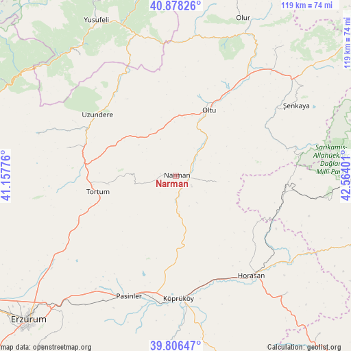
Narman GPS coordinates[2]
40° 20' 40.164" North, 41° 51' 39.168" East
| Map corner | latitude | longitude |
|---|---|---|
| Upper-left | 40.87826°, | 41.15776° |
| Center: | 40.34449°, | 41.86088° |
| Lower-right: | 39.80647°, | 42.56401° |
| Map W x H: | 119.2×119.2 km | = 74.1×74.1mi |
| max Lat: | 42.02683° ⇑24.8% North |
| Narman: | 40.34449° |
| min Lat: | ⇓75.2% South 35.9025° |
| min Long | Narman | max Long |
| 25.90902° | 41.86088° | 44.60099° |
| W 89%⇐ | ⇒11% E |
Elevation
Elevation of Narman is 1672 m = 5486 ft, and this is 954.6 m = 3132 ft above average elevation for this country.
| Max E: |
2682 m = 8799 ft | 5.2% |
| Narman | 1672 m 5486 ft | |
| Avg. | 717.4 m = 2354 ft | |
Min E: |
0 m = 0 ft | 94.8% |
See also: Turkey elevation on elevation.city.
Geographical zone
Narman is located in North temperate zone (between Tropic of Cancer and the Arctic Circle). Distance of this Northern Tropic circle is 1880 km =1168.2 mi to South.| Distance of | km | miles | from Narman |
|---|---|---|---|
| North Pole | 5521.2 | 3430.7 | to North |
| Arctic Circle | 2915.3 | 1811.5 | to North |
| Tropic Cancer | 1880 | 1168.2 | to South |
| Equator | 4485.9 | 2787.4 | to South |


Nearby cities:
15 places around Narman: (largest is in red/bold)
• Akşar
52.6 km =32.7 mi,  50°
50°
• Dumlu
53.3 km =33.1 mi,  233°
233°
• Gaziler
42.1 km =26.2 mi,  78°
78°
• Horasan
42.6 km =26.5 mi,  142°
142°
• Karaurgan
36.8 km =22.9 mi,  108°
108°
• Köprüköy
42.1 km =26.2 mi,  179°
179°
• Kılıçkaya
51.7 km =32.1 mi,  320°
320°
• Kışlaköy
13.9 km =8.6 mi,  99°
99°
• Oltu
24.2 km =15 mi,  26°
26°
• Pasinler
43.7 km =27.2 mi,  201°
201°
• Tortum
27.8 km =17.3 mi,  257°
257°
• Uzundere
34.4 km =21.4 mi,  307°
307°
• Çiftlik
45.2 km =28.1 mi,  132°
132°
• Şenkaya
47.1 km =29.3 mi,  59°
59°
• Şenyurt
37.8 km =23.5 mi,  283°
283°
Sources, notices
• [Note1] Compared only with cities in Turkey existing in our database
• [Src1] Map data: © OpenStreetMap contributors (CC-BY-SA)
• [Src2] Other city data from geonames.org with taken over terms of usage.
• [Src3] Geographical zone / Annual Mean Temperature by Robert A. Rohde @ Wikipedia
