Tekke geodata
Tekke (Amasya) is a seat of a third-order administrative division; located in Turkey in Europe/Istanbul (GMT+3) time zone. In our database, there are 1323 cities with bigger population. Compared to other cities in Turkey, 81.5% of cities are located further ↓South; 52.2% of cities are located further ←West and 68.1% of cities have higher elevation than Tekke. Note1


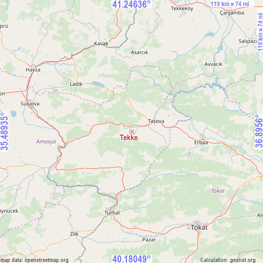
Tekke GPS coordinates[2]
40° 42' 56.016" North, 36° 11' 32.892" East
| Map corner | latitude | longitude |
|---|---|---|
| Upper-left | 41.24636°, | 35.48935° |
| Center: | 40.71556°, | 36.19247° |
| Lower-right: | 40.18049°, | 36.8956° |
| Map W x H: | 118.5×118.5 km | = 73.6×73.6mi |
| max Lat: | 42.02683° ⇑18.5% North |
| Tekke: | 40.71556° |
| min Lat: | ⇓81.5% South 35.9025° |
| min Long | Tekke | max Long |
| 25.90902° | 36.19247° | 44.60099° |
| W 52.2%⇐ | ⇒47.8% E |
Elevation
Elevation of Tekke is 357 m = 1171 ft, and this is 360.4 m = 1182 ft below average elevation for this country.
| Max E: |
2682 m = 8799 ft | 68.1% |
| Avg. | 717.4 m = 2354 ft | |
| Tekke | 357 m = 1171 ft | |
Min E: |
0 m = 0 ft | 31.9% |
See also: Turkey elevation on elevation.city.
Geographical zone
Tekke is located in North temperate zone (between Tropic of Cancer and the Arctic Circle). Distance of this Northern Tropic circle is 1921.2 km =1193.8 mi to South.| Distance of | km | miles | from Tekke |
|---|---|---|---|
| North Pole | 5479.9 | 3405.1 | to North |
| Arctic Circle | 2874 | 1785.8 | to North |
| Tropic Cancer | 1921.2 | 1193.8 | to South |
| Equator | 4527.1 | 2813 | to South |


Nearby cities:
15 places around Tekke: (largest is in red/bold)
• Akdağ
18.2 km =11.3 mi,  268°
268°
• Amasya
31.1 km =19.3 mi,  257°
257°
• Asarcık
35.8 km =22.2 mi,  5°
5°
• Destek
14.6 km =9.1 mi,  356°
356°
• Doğanyurt
44.3 km =27.5 mi,  93°
93°
• Erbaa
32 km =19.9 mi,  99°
99°
• Esençay
16.7 km =10.4 mi,  108°
108°
• Ezinepazarı
16.8 km =10.4 mi,  195°
195°
• Karayaka
33.7 km =20.9 mi,  84°
84°
• Kavak
42.3 km =26.3 mi,  342°
342°
• Kozlu
26.9 km =16.7 mi,  116°
116°
• Ladik
33.3 km =20.7 mi,  310°
310°
• Taşova
12 km =7.5 mi,  65°
65°
• Turhal
37.7 km =23.4 mi,  194°
194°
• Şeyhli
25.4 km =15.8 mi,  334°
334°
Sources, notices
• [Note1] Compared only with cities in Turkey existing in our database
• [Src1] Map data: © OpenStreetMap contributors (CC-BY-SA)
• [Src2] Other city data from geonames.org with taken over terms of usage.
• [Src3] Geographical zone / Annual Mean Temperature by Robert A. Rohde @ Wikipedia
