Taşova geodata
Taşova (Amasya) is a seat of a second-order administrative division; located in Turkey in Europe/Istanbul (GMT+3) time zone. With population of 19,253 people, there are 341 cities with bigger population in this country. Compared to other cities in Turkey, 82.6% of cities are located further ↓South; 53.5% of cities are located further ←West and 71.8% of cities have higher elevation than Taşova. Note1


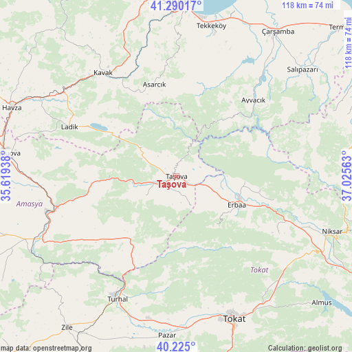
Taşova GPS coordinates[2]
40° 45' 34.992" North, 36° 19' 21" East
| Map corner | latitude | longitude |
|---|---|---|
| Upper-left | 41.29017°, | 35.61938° |
| Center: | 40.75972°, | 36.3225° |
| Lower-right: | 40.225°, | 37.02563° |
| Map W x H: | 118.4×118.4 km | = 73.6×73.6mi |
| max Lat: | 42.02683° ⇑17.4% North |
| Taşova: | 40.75972° |
| min Lat: | ⇓82.6% South 35.9025° |
| min Long | Taşova | max Long |
| 25.90902° | 36.3225° | 44.60099° |
| W 53.5%⇐ | ⇒46.5% E |
Elevation
Elevation of Taşova is 241 m = 791 ft, and this is 476.4 m = 1563 ft below average elevation for this country.
| Max E: |
2682 m = 8799 ft | 71.8% |
| Avg. | 717.4 m = 2354 ft | |
| Taşova | 241 m = 791 ft | |
Min E: |
0 m = 0 ft | 28.2% |
See also: Turkey elevation on elevation.city.
Geographical zone
Taşova is located in North temperate zone (between Tropic of Cancer and the Arctic Circle). Distance of this Northern Tropic circle is 1926.1 km =1196.8 mi to South.| Distance of | km | miles | from Taşova |
|---|---|---|---|
| North Pole | 5475 | 3402 | to North |
| Arctic Circle | 2869.1 | 1782.8 | to North |
| Tropic Cancer | 1926.1 | 1196.8 | to South |
| Equator | 4532.1 | 2816.1 | to South |


Nearby cities:
15 places around Taşova: (largest is in red/bold)
• Akdağ
29.7 km =18.5 mi,  259°
259°
• Asarcık
31.5 km =19.6 mi,  346°
346°
• Ayvacık
36.6 km =22.7 mi,  45°
45°
• Destek
15.2 km =9.4 mi,  309°
309°
• Doğanyurt
34.1 km =21.2 mi,  103°
103°
• Erbaa
23 km =14.3 mi,  116°
116°
• Esençay
11.3 km =7 mi,  154°
154°
• Ezinepazarı
26.2 km =16.3 mi,  216°
216°
• Gökçeli
39.8 km =24.7 mi, 119°
• Karayaka
22.6 km =14 mi,  94°
94°
• Kavak
42.5 km =26.4 mi,  326°
326°
• Kozlu
21.3 km =13.2 mi,  141°
141°
• Ladik
39.9 km =24.8 mi,  294°
294°
• Tekke
12 km =7.5 mi,  245°
245°
• Şeyhli
28.3 km =17.6 mi, 309°
Sources, notices
• [Note1] Compared only with cities in Turkey existing in our database
• [Src1] Map data: © OpenStreetMap contributors (CC-BY-SA)
• [Src2] Other city data from geonames.org with taken over terms of usage.
• [Src3] Geographical zone / Annual Mean Temperature by Robert A. Rohde @ Wikipedia
